Sierra de los Cuchumatanes
| Sierra de los Cuchumatanes | |
|---|---|
 | |
| Highest point | |
| Peak | La Torre (Todos Santos Cuchumatán) |
| Elevation | 3,837 m (12,589 ft) |
| Coordinates | 15°31′10″N 91°32′41″W / 15.51944°N 91.54472°WCoordinates: 15°31′10″N 91°32′41″W / 15.51944°N 91.54472°W |
| Dimensions | |
| Area | 16,350 km2 (6,310 sq mi) |
| Geography | |
 Sierra de los Cuchumatanes | |
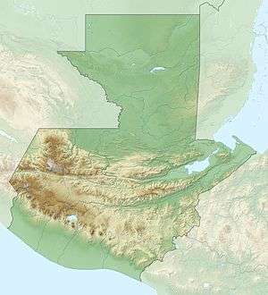
| Country | Guatemala |
| States/Provinces | Huehuetenango and El Quiché |
| Geology | |
| Age of rock | Paleozoic to Mesozoic |
| Type of rock | Karst and sedimentary rock |
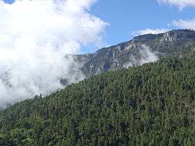
The Sierra de los Cuchumatanes is the highest non-volcanic mountain range in Central America. Its elevations range from 500 m (1,600 ft) to over 3,800 m (12,500 ft), and it covers a total area of c. 16,350 km2 (6,310 sq mi).[1] With an area of 1,500 km2 (580 sq mi) situated above 3,000 m (9,800 ft), it is also the most extensive highland region in Central America.[2][3] The Sierra de los Cuchumatanes is located in western Guatemala in the departments of Huehuetenango and El Quiché. Its western and south-western borders are marked by the Seleguá River, which separates it from the Sierra Madre volcanic chain. Its southern border is defined by the Río Negro, which flows into the Chixoy River, which turns northwards and separates the Cuchumatanes from the mountains in the Alta Verapaz region. The highest peaks, which reach up to 3,837 m (12,589 ft),[4] are located in the department of Huehuetenango.
The name "Cuchumatán" is derived from the Mam words cuchuj (to join or unite) and matán (with superior force) and means "that which was brought together by superior force". Cuchumatán may also be a derivation of the Nahuatl word kochmatlán, which means "place of the parrot hunters".[1]
The Cuchumatanes has a variety of different biomes, including pine-oak lower montane and montane humid forest, while lower montane wet forest and neotropic grass- and shrublands are present on higher slopes and plateaus,[5] and subtropical pluvial forest in the northern piemonte.[2]
Notes
- 1 2 Lovell 2005:11
- 1 2 "Ecosystem Profile: Northern Region, Mesoamerica - Cuchumatanes key biodiversity area". Critical Ecosystem Partnership Fund. Archived from the original on 2010-03-23. Retrieved 2009-06-16.
- ↑ Marshall 2007:1-31
- ↑ "31 Mountains with Prominence of 1,500 meters or greater". Central America and Caribbean Ultra-Prominence Page. Peaklist. Retrieved 2012-10-28.
- ↑ Steinberg & Taylor 2008
References
- Caffrey, Maria A. (2007). A 10,000 Year Record of Pre-Columbian Environmental Change from Highland Guatemala. Thesis. University of Denver. Archived from the original (pdf) on 2012-03-11.
- Lovell, William George (2005). Conquest and Survival in Colonial Guatemala: A Historical Geography of the Cuchumatán Highlands, 1500-1821. Montreal/Kingston: McGill-Queen's University Press. ISBN 978-0-7735-2741-6.
- Marshall, Jeffrey S. (2007). "The Geomorphology and Physiographic Provinces of Central America" (PDF). In Bundschuh, Jochen & Guillermo E. Alvarado (Eds). Central America: Geology, Resources and Hazards (pdf)
|format=requires|url=(help). Taylor & Francis. pp. 1–30. ISBN 978-0-415-41647-4.
- Steinberg, Michael and Matthew Taylor (2008). "Guatemala's Altos de Chiantla: Changes on the High Frontier". Mountain Research and Development. 28 (3/4): 255–262. doi:10.1659/mrd.0891. ISSN 1994-7151.
External links
![]()