Siege of Burnswark
| Siege of Burnswark | |||||||
|---|---|---|---|---|---|---|---|
| Part of Roman conquest of Britain | |||||||
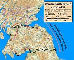 Scotland in 150 AD | |||||||
| |||||||
| Belligerents | |||||||
| Roman Empire | Selgovae | ||||||
| Commanders and leaders | |||||||
|
Antoninus Augustus Pius Quintus Lollius Urbicus | Unknown | ||||||
| Strength | |||||||
| 6,000+[1] | Unknown | ||||||
| Casualties and losses | |||||||
| Unknown | Unknown, suspected massacre | ||||||
The Siege of Burnswark Hill was a battle for control of a Caledonian hillfort fought between the defending Caledonian Selgovae tribe and Roman legions taking part in Quintus Lollius Urbicus' conquest of the Scottish Lowlands. The siege took place at present day Burnswark in southwestern Scotland near Lockerbie and resulted in a Roman victory.
Context
Little is known about the actual battle from historical texts save from its context which has been well documented. Much of what is known including troop positions and movements has been gleaned from archaeological work at the site of the battle.
After the death of the Emperor Publius Aelius Hadrianus, Antoninus Augustus Pius rose to the throne and moved quickly to reverse the empire limit system put in place by his predecessor. Following his defeat of the Brigantes in 139 AD,[2] Quintus Lollius Urbicus, the Roman Governor of Britannia,[3][4][5] was ordered by Antonius Pius to march north of Hadrian's Wall to conquer the Caledonian Lowlands which were settled by the Otadini, Selgovae, Damnonii and the Novantae, and to push the frontier further north. Lollius Urbicus moved three legions into position initially establishing his supply routes from Coria and Bremenium and moved three legions, the Legio II Augusta from Caerleon, the Legio VI Victrix from Eboracum, and the Legio XX Valeria Victrix from Deva Victrix into the theatre between 139 and 140 AD, and thereafter moved his army, a force of at least 16,500 men,[6] north of Hadrian's Wall.
The Selgovae, having settled in the regions of present day Kirkcudbrightshire and Dumfriesshire immediately northwest of Hadrian's Wall, were amongst the first of the Caledonian tribes to face Lollius Urbicus' legions together with the Otadini. The Romans, who were well versed in warfare on hilly terrain since their founding, moved quickly to occupy strategic points and high ground, some of which had already been fortified by the Caledonians with hill forts. One such hill fort was located at present day Burnswark which was strategically located commanding the western route north further into Caledonia.[1]
Battle details
The Roman forces set up positions surrounding the hill fort and made two encampments on either side of the fort to effectively cut it off.[7] It is believed that the two Roman camps housed around 6,000 soldiers composed of legions and auxiliary troops. Whereas the defenders would have been armed only with simple weapons, swords and shields, the Romans had complex siege weapons and made extensive use of slingers to deadly effect. It is believed that the defenders of the hill fort were almost entirely wiped out.[7]
Aftermath
This was likely one of many battles that took place during the Roman Campaign in the Caledonian Lowlands. By 142 AD, the Romans had pacified the entire area and had successfully moved the frontier north to the newly built Antonine Wall.
See also
References
- 1 2 Metcalfe, Tom (13 June 2016). "In Photos: 1,800-Year-Old Roman Battle Site". livescience.com. Live Science. Retrieved 2 June 2017.
- ↑ "Roman Timeline 2nd Century AD". unrv.com. UNRV. Retrieved 1 June 2017.
- ↑ W. Eck, Die Statthalter der germanischen Provinzen vom 1.-3. Jahrhundert (Epigraphische Studien Band 14, Cologne/Bonn, 1985, p. 168.
- ↑ Historia Augusta, Antoninus Pius 5.4.
- ↑ Freeman, Charles (1999) Egypt, Greece, and Rome. Oxford University Press. p. 508. ISBN 0-19-872194-3.
- ↑ Hanson, William S. "The Roman Presence: Brief Interludes", in Edwards, Kevin J. & Ralston, Ian B.M. (Eds) (2003) Scotland After the Ice Age: Environment, Archaeology and History, 8000 BC – AD 1000. Edinburgh. Edinburgh University Press.
- 1 2 Pringle, Heather (24 May 2017). "Ancient Slingshot Was as Deadly as a .44 Magnum". nationalgeographic.com. National Geographic. Retrieved 2 June 2017.
Further reading
- A.J. Woodman (with C. Kraus), Tacitus: Agricola, Cambridge: Cambridge University Press, 2014.
Coordinates: 55°05′49″N 3°16′34″W / 55.096873°N 3.276126°W