Siazan District
| Siyazan | |
|---|---|
| Rayon | |
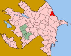 Map of Azerbaijan showing Siyazan Rayon | |
| Country | Azerbaijan |
| Capital | Siyəzən |
| Area[1][2] | |
| • Total | 700 km2 (300 sq mi) |
| Population (2011)[3] | |
| • Total | 38,400 |
| Telephone code | 99423 |
Siyazan or Siazan (Azerbaijani: Siyəzən) is an rayon in Azerbaijan, capital Siyəzən.The word Siyazan means "black female" in Tati.[4] The area has population 37,900 (2010 census).
History
In the territory of Siyazan region, there were previously villages called Agh Siyazan and Gara Siyazan. The city was formerly called Gizilburun. These territories were previously a dry desert. When the Baku-Shollar Pipeline was being constructed between 1911 and 1196, people moved here from the surrounding villages as labor force. The "Gızılburun" railway station also played a role in the transformation of these places as a residential area.
Between 1938 and 1939, geologists discovered oil deposits in the Siyazan district. After the first oil wells were drilled in the area, many people from different places of Azerbaijan began to settle here.
For the first time Siyazan Rayon was originated on February 11, 1940. The first head of the district was Hanifa Huseynov. In 1959, it was eliminated and included into Shabran Rayon. On April 2, 1992 borders of Siyazan Rayon were restored by the order of Supreme Soviet of Azerbaijan. Until February 11, 1939 Siyazan Rayon was a part of Absheron Rayon. From 1939 to 1959, Khizi and Siyazan Rayons were a single rayon. Gizilburun, later renamed to Siyazan in 1954, was its center. In 1992, the status of the rayon was re-established, but Chirag-gala and Aghbash sanatoriums were given to Davachi Rayon (the given settlements are in the territory of Siyazan Rayon).[5]
Geography
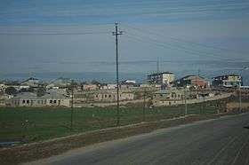
The rayon is located in the eastern part of Azerbaijan, in Samur-Davachi lowland, on the shore of the Caspian Sea near Greater Caucasus. It borders upon Khizi and Shabran Rayons. Greater Caucasus Mountain ridge crosses western part of the lowland extending along the Caspian Sea. Its latitude is 28 m. Beshbarmag Mountain is its most well-known mountain with an altitude of 500 m. Geological structure and sedimentation detected in the territory of the rayon is dated to Paleogene and Neogene periods.
Surface of the lowland’s south-western part makes up a semi-desert landscape. Meadow and forest landscapes are typical for its mountainous parts, where grey meadow and chestnut-brown soils spread. The Atachay and Gilgilchay Rivers flowing through the territory of the rayon spring from mountainous parts. Snow and rain swell the rivers.[6]
The climate in the rayon is moderately warm and dry subtropical. The average temperature is from 1.5 °C to 4 °C in January, up to 15°C and 25°C respectively in July. Summer is dry. The annual rainfall is 300-650 mm. The lands are mainly gray-brown soils.[7]
Demographics
The population of Siyazan district is 40.5 thousand (January 1, 2015). The rural population (33.39%) is relatively small compared to the urban population (65.61%) (April 13-22, 2009). Of the total population, 49.8% are men and 50.2% are women. According to the 2009 census, the population is mainly Azerbaijanis. But representatives of Lezgins, Russians, Turkish people, Tatars, Ukrainians and other nationalities also live in the region.[8]
Economy
Industry: Siyazan is and industrial district. The main natural resources are oil, natural gas, sand, gravel, clay. The mining industry prevails in the economy.
There are 4 large and medium, 8 small industrial enterprises, two flour mills owned by individual entrepreneurs, bakery shops, furniture shops, plastic goods production shops in the area of the district.
In 2016, products worth AZN 11121.2 thousand were produced. 61.3% of the total volume of industrial production belong to the state ownership, 38.3% - private property, and 0.4% - private entrepreneurs producing industrial products.
In 2016 natural gas pipes and pipes were produced and 52.1 thousand tons of oil, 10.1 million cubic meters of gas was sold. In 2016, the average number of workers in the industry was 1250, average wage was 678.4 manat.
Agriculture: 38,11 hectares of land in 70,300 hectares are agricultural land, including 8,900 hectares of sown area. Grain and livestock farming dominate in agriculture. There are 6 agricultural enterprises, including Siyazan-Broiler, a large poultry farm, and 56 individual entrepreneurships.
In 2016 in the region agricultural products were produced in the amount of 72184,8 thousand manats. 5.8% of the production was made by plants, 94.2% by the hygiene products.
In 2016 the region harvested 6083,0 tons of grain, 195,1 tons of corn, 358,0 tons of potatoes, 1148,0 tons of vegetables, 1002,0 tons of melons, 1202 tons of fruits and 242 tons of grapes. 100 hectares of nuts, 18 hectares of olive has been planted.
In early 2017, the number of cattle in the region was 13024, the number of sheep and goats was 54375. 19066.9 tons of meat, including 16924.9 tons of poultry, 12287 tons of milk, 12.3 million eggs and 89 tons of wool were produced in the live weight.
Culture, education and healthcare facilities
There are six secondary schools, a sports school. a music school and a boarding school in the city of Siyazan. In the center of Siyazan district, the central hospital, diagnostic center (regional), central polyclinic, children's hospital operate.
Cultural heritage
Flexible parabolic barrier (IV-VII centuries) - This fortification extends from the skirts of Beshbarmak to the Caspian Sea.
Gil-gilchay defense fortress complex (V century) - is surrounded by the Chirag Fortress, passing through Yenikend, Kolani, Eynibulag, Dashli Calghan, Gala-six villages of Siyazan district.
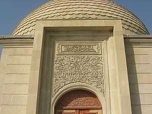
Pir Khalil Tomb (XVIII century) - is located in Gil-Gilchay settlement. Until the present time, he survived.
The remains of the castle - Religious tower belonging to the middle ages
The Sheikh Heydar Tomb (XV century) - is located in the village cemetery in the west of the ancient Shikhlar village.
Remains of Caravanserai (XV-XVII centuries) - is located on the right side of Baku-Devechi highway, 87 km far away from Baku
The town (medieval) is located in the northern part of Siyazan city
Waterfall - located near the village of Zarat
Stone cave- located in village of Dib
Gil-Gilchay railway station (1898)
Zarat railway station (1913)
Water Pipeline (1906) - is located near the city of Siyazan.
Golubbur railway station - was constructed in 1913
An ancient water reservoir - was constructed in 1913 and is located near the Gizilburun station.
Hidir Zinja Mausoleum (Beshbarmaq)
Memorial monuments:
Statue of Jafar Jabbarli
Statue of Mikayil Mushviq
"1941-1945" Monument Complex
"20 January" Monument Complex
"Neftchi Martyrs" Monument Complex
References
- ↑ "Siyəzən rayonu".
- ↑ "Siyazan rayonu". Archived from the original on 2013-04-15.
- ↑ "Siyəzən rayonu". The State Statistical Committee of the Republic of Azerbaijan. Archived from the original on 2012-05-11.
- ↑ http://www.azerb.com/az-siazan.html?ckattempt=1
- ↑ "Сиязаньский район". azerbaijan.az.
- ↑ "Siyazan". discoverazerbaijan.az. Archived from the original on 2013-09-02.
- ↑ "Siyazan district".
- ↑ "Information on the administrative-territorial unit :Siyazan".