Shpykiv
| Shpykiv | |
|---|---|
| Urban-type settlement | |
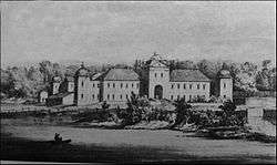 Świejkowski Palace in the 19th century | |
 Shpykiv  Shpykiv | |
| Coordinates: 48°47′N 28°34′E / 48.783°N 28.567°ECoordinates: 48°47′N 28°34′E / 48.783°N 28.567°E | |
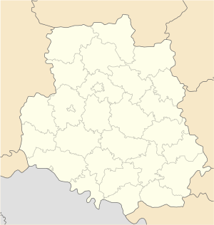
| Country |
|
| Province |
|
| District | Tulchyn Raion |
| Founded | 1507 |
| Area | |
| • Total | 4,5 km2 (17 sq mi) |
| Population (2015) | |
| • Total | 3,284 |
| • Density | 73/km2 (190/sq mi) |
| Time zone | UTC+2 (EET) |
| • Summer (DST) | UTC+3 (EEST) |
Shpykiv (Ukrainian: Шпиків, Polish: Szpików) is an urban-type settlement in Tulchyn Raion (a district in Vinnytsia Oblast (province) in central Ukraine, 372 kilometers (231 mi) southwest of Kiev and 24 km (15 mi) northwest of Tulchyn, the raion center. Population: 3,284 (2015 est.)[1]. It is located in the historic region of Podolia.
History
![]()
![]()
![]()
![]()
![]()
![]()
![]()
![]()
![]()
![]()
Until the Partitions of Poland Szpików was part of the Bracław Voivodeship of the Lesser Poland Province of the Polish Crown. It was a small town, owned by the houses of Ostrogski, Zamoyski, Koniecpolski, Potocki and Świejkowski[2]. Leonard Marcin Świejkowski built a Baroque palace in Szpików.
It formerly had a significant Jewish community, which numbered 1,875 in 1900.
References
- ↑ "Чисельність наявного населення України (Actual population of Ukraine)" (PDF) (in Ukrainian). State Statistics Service of Ukraine. Retrieved 1 July 2016.
- ↑ Geographical Dictionary of the Kingdom of Poland, vol. 12, p. 29
| Raions | |||||
|---|---|---|---|---|---|
| Cities |
| ||||
| |||||