Shirinsky District
| Shirinsky District Ширинский район (Russian) Сыра аймағы (Khakas) | |
|---|---|
 Location of Shirinsky District in the Republic of Khakassia | |
| Coordinates: 54°26′10″N 88°41′35″E / 54.436°N 88.693°ECoordinates: 54°26′10″N 88°41′35″E / 54.436°N 88.693°E | |
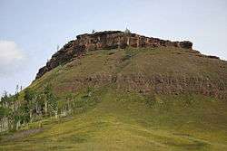 Ruins of the Chebaki Fortress near the village of Chebaki in Shirinsky District | |
.png) | |
|
| |
| Location | |
| Country | Russia |
| Federal subject | Republic of Khakassia[1] |
| Administrative structure (as of February 2013) | |
| Administrative center | selo of Shira[1] |
| Administrative divisions:[1] | |
| selsoviet | 15 |
| Inhabited localities:[1] | |
| Rural localities | 38 |
| Municipal structure (as of February 2013) | |
| Municipally incorporated as | Shirinsky Municipal District[2] |
| Municipal divisions:[2] | |
| Urban settlements | 0 |
| Rural settlements | 15 |
| Statistics | |
| Area | 6,880 km2 (2,660 sq mi) |
| Population (2010 Census) | 29,371 inhabitants[3] |
| • Urban | 2.8% |
| • Rural | 97.2% |
| Density | 4.27/km2 (11.1/sq mi)[4] |
| Time zone | KRAT (UTC+07:00)[5] |
| Official website | |
| Shirinsky District on WikiCommons | |
Shirinsky District (Russian: Шири́нский райо́н; Khakas: Сыра аймағы, Sıra aymağı) is an administrative[1] and municipal[2] district (raion), one of the eight in the Republic of Khakassia, Russia. It is located in the north of the republic. The area of the district is 6,880 square kilometers (2,660 sq mi). Its administrative center is the rural locality (a selo) of Shira.[1] Population: 29,371 (2010 Census);[3] 31,720 (2002 Census);[6] 39,385 (1989 Census).[7] The population of Shira accounts for 32.2% of the district's total population.[3]
References
Notes
- 1 2 3 4 5 6 Law #20
- 1 2 3 Law #63
- 1 2 3 Russian Federal State Statistics Service (2011). "Всероссийская перепись населения 2010 года. Том 1" [2010 All-Russian Population Census, vol. 1]. Всероссийская перепись населения 2010 года (2010 All-Russia Population Census) (in Russian). Federal State Statistics Service. Retrieved June 29, 2012.
- ↑ The value of density was calculated automatically by dividing the 2010 Census population by the area specified in the infobox. Please note that this value is only approximate as the area specified in the infobox does not necessarily correspond to the area of the entity proper or is reported for the same year as the population.
- ↑ Правительство Российской Федерации. Федеральный закон №107-ФЗ от 3 июня 2011 г. «Об исчислении времени», в ред. Федерального закона №271-ФЗ от 03 июля 2016 г. «О внесении изменений в Федеральный закон "Об исчислении времени"». Вступил в силу по истечении шестидесяти дней после дня официального опубликования (6 августа 2011 г.). Опубликован: "Российская газета", №120, 6 июня 2011 г. (Government of the Russian Federation. Federal Law #107-FZ of June 31, 2011 On Calculating Time, as amended by the Federal Law #271-FZ of July 03, 2016 On Amending Federal Law "On Calculating Time". Effective as of after sixty days following the day of the official publication.).
- ↑ Russian Federal State Statistics Service (May 21, 2004). "Численность населения России, субъектов Российской Федерации в составе федеральных округов, районов, городских поселений, сельских населённых пунктов – районных центров и сельских населённых пунктов с населением 3 тысячи и более человек" [Population of Russia, Its Federal Districts, Federal Subjects, Districts, Urban Localities, Rural Localities—Administrative Centers, and Rural Localities with Population of Over 3,000] (XLS). Всероссийская перепись населения 2002 года [All-Russia Population Census of 2002] (in Russian). Retrieved August 9, 2014.
- ↑ Demoscope Weekly (1989). "Всесоюзная перепись населения 1989 г. Численность наличного населения союзных и автономных республик, автономных областей и округов, краёв, областей, районов, городских поселений и сёл-райцентров" [All Union Population Census of 1989: Present Population of Union and Autonomous Republics, Autonomous Oblasts and Okrugs, Krais, Oblasts, Districts, Urban Settlements, and Villages Serving as District Administrative Centers]. Всесоюзная перепись населения 1989 года [All-Union Population Census of 1989] (in Russian). Институт демографии Национального исследовательского университета: Высшая школа экономики [Institute of Demography at the National Research University: Higher School of Economics]. Retrieved August 9, 2014.
Sources
- Верховный Совет Республики Хакасия. Закон №20 от 5 мая 2004 г. «Об административно-территориальном устройстве Республики Хакасия», в ред. Закона №54-ЗРХ от 10 июня 2015 г. «О внесении изменений в Закон Республики Хакасия "Об административно-территориальном устройстве Республики Хакасия"». Вступил в силу по истечении 10 дней со дня официального опубликования. Опубликован: "Вестник Хакасии", №22, 12 мая 2004 г. (Supreme Council of the Republic of Khakassia. Law #20 of May 5, 2004 On the Administrative-Territorial Structure of the Republic of Khakassia, as amended by the Law #54-ZRKh of June 10, 2015 On Amending the Law of the Republic of Khakassia "On the Administrative-Territorial Structure of the Republic of Khakassia". Effective as of the day which is 10 days after the official publication date.).
- Верховный Совет Республики Хакасия. Закон №63 от 7 октября 2004 г. «Об утверждении границ муниципальных образований Ширинского района и наделении их соответственно статусом муниципального района, сельского поселения», в ред. Закона №11-ЗРХ от 11 марта 2015 г. «О внесении изменения в статью 3 Закона Республики Хасасия "Об утверждении границ муниципальных образований Ширинского района и наделении их соответственно статусом муниципального района, городского, сельского поселения"». Вступил в силу с 1 января 2005 г. Опубликован: "Вестник Хакасии", №48, 15 октября 2004 г. (Supreme Council of the Republic of Khakassia. Law #63 of October 7, 2004 On the Adoption of the Borders of the Municipal Formations of Shirinsky District and on Granting Them a Status, Correspondingly, of a Municipal District, a Rural Settlement, as amended by the Law #11-ZRKh of March 11, 2015 On Amending Article 3 of the Law of the Republic of Khakassia "On the Adoption of the Borders of the Municipal Formations of Shirinsky District and on Granting Them a Status, Correspondingly, of a Municipal District, an Urban Settlement, a Rural Settlement". Effective as of January 1, 2005.).
 | Districts | ||
|---|---|---|---|
| Cities and towns | |||
| Urban-type settlements | |||
This article is issued from
Wikipedia.
The text is licensed under Creative Commons - Attribution - Sharealike.
Additional terms may apply for the media files.