Shire River
| Shire River | |
| River | |
 | |
| Countries | Malawi, Mozambique |
|---|---|
| Source | Lake Malawi |
| - elevation | 474 m (1,555 ft) |
| - coordinates | 14°25′25″S 35°14′10″E / 14.42361°S 35.23611°E |
| Mouth | Zambezi |
| - coordinates | 17°41′36″S 35°18′55″E / 17.69333°S 35.31528°ECoordinates: 17°41′36″S 35°18′55″E / 17.69333°S 35.31528°E |
| Length | 402 km (250 mi) |
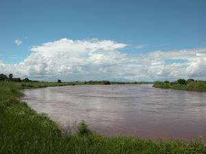
The Shire is the largest river in Malawi. The river has been known as the Shiré or Chire River. It is the only outlet of Lake Malawi and flows into the Zambezi River in Mozambique. Its length is 402 kilometres (250 mi). The upper Shire River issues from Lake Malawi and runs approximately 12 miles before it enters shallow Lake Malombe. It then drains Lake Malombe and flows south through Liwonde National Park where large concentrations of hippopotamus are common along its shores. Between the towns of Matope and Chikwawa, the middle river drops approximately 1,300 feet through a series of falls and gorges. Two hydroelectric dams have been built along the Shire northwest of Blantyre.
Beyond Chikwawa, the lower river turns southeast and enters the low-lying Mozambique plain. Its largest and one of its few perennial tributaries, the Ruo River, joins the Shire near the Malawian town of Chiromo. The muddy waters pass through a large stagnant area known as the Elephant Marsh before reaching the confluence with the Zambezi River south of the town of Sena, Mozambique.
In 1859, David Livingstone's Zambezi Expedition traveled up the Shire river.[1]
The river's valley is part of the East African Rift system.[2]

References
- ↑ Briggs, Philip (2016). Malawi. Bradt Travel Guides. p. 9. ISBN 9781784770143.
- ↑ Live Search Maps