Shinyanga Rural District
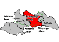
Map of Shinyanga's Districts
Shinyanga Rural District is one of the eight districts of the Shinyanga Region of Tanzania. It is bordered to the north by the Shinyanga Urban District, to the east by the Kishapu District, to the south by the Tabora Region, and to the west by the Kahama District.
According to the 2002 Tanzania National Census, the population of the Shinyanga Rural District was 277,518.
Wards
The Shinyanga Rural District is administratively divided into 16 wards:
- Didia
- Ilola
- Imesela
- Iselamagazi
- Itwangi
- Lyabukande
- Mwakitolyo
- Mwamala
- Mwantini
- Pandagichiza
- Salawe
- Samuye
- Solwa
- Tinde
- Usanda
- Usule
Sources
This article is issued from
Wikipedia.
The text is licensed under Creative Commons - Attribution - Sharealike.
Additional terms may apply for the media files.