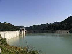
Shimokubo Dam
| Shimokubo Dam | |
|---|---|
|
| |
| Location | Gunma Prefecture, Japan. |
| Coordinates | 36°07′57″N 139°01′21″E / 36.13250°N 139.02250°ECoordinates: 36°07′57″N 139°01′21″E / 36.13250°N 139.02250°E |
| Construction began | 1959 |
| Opening date | 1968 |
| Dam and spillways | |
| Impounds | Kanna River |
| Height | 129 m |
| Length | 605 m |
| Reservoir | |
| Total capacity | 130,000,000 m³ |
| Catchment area | 322.9 km² |
| Surface area | 327 hectares |
Shimokubo Dam is a dam in the Gunma Prefecture of Japan,[1] completed in 1968.[2]
References
- ↑ "Hydropower & Dams in South and East Asia" (PDF). Hydropower and Dams. p. 9. Retrieved 3 October 2010.
- ↑ http://damnet.or.jp/cgi-bin/binranA/enAll.cgi?db4=0615
| Wikimedia Commons has media related to Shimokubo Dam. |
This article is issued from
Wikipedia.
The text is licensed under Creative Commons - Attribution - Sharealike.
Additional terms may apply for the media files.