Sheep Creek Range
| Sheep Creek Range | |
|---|---|
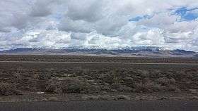 The Sheep Creek Range northeast of Battle Mountain | |
| Highest point | |
| Peak | Sterritt Peak |
| Elevation | 2,217.72 m (7,276.0 ft) |
| Geography | |
| Country | United States |
| State | Nevada |
| District | Lander County |
| Range coordinates | 40°49′33.673″N 116°43′16.348″W / 40.82602028°N 116.72120778°WCoordinates: 40°49′33.673″N 116°43′16.348″W / 40.82602028°N 116.72120778°W |
| Topo map | USGS Sheep Creek Range SW |

The Sheep Creek Range is a mountain range in Lander County, Nevada northeast of Battle Mountain. It is the site of a doppler radar station.
References
- ↑ "Sheep Creek Range". Geographic Names Information System. United States Geological Survey. Retrieved 2009-05-04.
This article is issued from
Wikipedia.
The text is licensed under Creative Commons - Attribution - Sharealike.
Additional terms may apply for the media files.