Sexton's Burrows
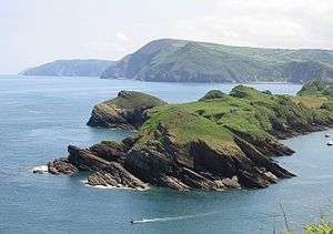
This photograph was taken from Widmouth Head looking east. In the distance, the shoreline shows the very high cliffs where Exmoor meets the sea.
Sexton's Burrows is a narrow rocky peninsula which forms a natural breakwater to the Harbour of Watermouth Bay on the North Devon coast.
Coordinates: 51°13′02″N 4°04′31″W / 51.2172°N 4.0754°W
This article is issued from
Wikipedia.
The text is licensed under Creative Commons - Attribution - Sharealike.
Additional terms may apply for the media files.