Seven Arches Bridge (Newport)
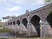
The Seven Arches Bridge is a historic bridge in Newport, County Mayo, Ireland.
Built around 1892, the bridge is a seven span squared red sandstone structure with limestone detailing over the Black Oak River/Newport River. It carried the Achill branch of the Midland Great Western Railway line,[1] with the last train running on this line in the autumn of 1937.[2] It was recently restored as part of the Great Western Greenway, the longest off-road cycling & walking route in Ireland.[3]
The bridge is listed as a Protected Structure for County Mayo, number 112.[1]
Technical Details
The single track viaduct has an overall length of 305 feet (93 m) and width 18 ft 6 in (5.64 m).[4] The seven segmental arches have a 37-foot (11 m) span, with a rise of 12 ft 6 in (3.81 m). The arch rings are 24 inches thick (61 cm). The bridge piers are 6 ft (1.8 m) thick with pointed cutwaters.[5] The cost of the viaduct was over £7,000.[6]
The rail line over the viaduct was not opened until 1894 pending completion of a nearby tunnel.[4]
References
- 1 2 Mayo County Development Plan 2014 – 2020, Volume 4, List of Structures on the Record of Protected Structures for County Mayo (Technical report). Mayo County Council. 2014. Proposed Amendment V4.
- ↑ "Heritage Trail - RAILWAY VIADUCT". newportmayo.ie. Department of the Environment, Community and Local Government. 2007–2013. Retrieved March 31, 2014.
- ↑ Joseph Mischyshyn (2013). "Newport - County Mayo - Seven Arch Railway Viaduct over Black Oak River". geograph.ie. Retrieved March 27, 2014.
- 1 2 "Realised Vision-Railways". www.realizedvision.com. Institution of Engineers of Ireland. 2000. Retrieved March 31, 2014.
- ↑ Cox, Ronald C. (1998). Civil Engineering Heritage: Ireland. Thomas Telford. p. 297. ISBN 0-7277-2627-7. Retrieved March 31, 2014.
- ↑ "Bridges". www.askaboutireland.ie. Changing Libraries Initiative and the Department of the Environment, Community and Local Government. 2014. Retrieved March 31, 2014.
External links
| Wikimedia Commons has media related to Seven Arches Bridge (Newport). |