Serra de la Llena
| Serra de la Llena | |
|---|---|
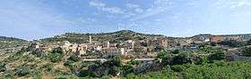 The Serra de la Llena above Vilanova de Prades | |
| Highest point | |
| Elevation | 1,021 m (3,350 ft) |
| Coordinates | 41°20′36″N 0°53′32″E / 41.34333°N 0.89222°ECoordinates: 41°20′36″N 0°53′32″E / 41.34333°N 0.89222°E |
| Geography | |
 Serra de la Llena Location in Spain | |
| Location | Conca de Barberà, Garrigues, Priorat, (Catalonia) |
| Parent range | Catalan Pre-Coastal Range |
| Geology | |
| Mountain type | Conglomerate |
| Climbing | |
| Easiest route | From Vilanova de Prades |
Serra de la Llena, also known as Serra la Llena, is a mountain chain straddling the municipal terms of Vilanova de Prades (Conca de Barberà comarca), La Pobla de Cérvoles (Garrigues) and Ulldemolins (Priorat), in Catalonia, Spain. These mountains have characteristic large and rounded rocky outcrops.
The range runs in an east to west direction and is part of the Catalan Pre-Coastal Range. The main peak is Punta del Curull (1021 m), other summits are Penya Alta (1015 m), Punta del General (924 m), Punta de Viern (904 m), Punta del Moliner (902 m), Punta del Marc (901 m), Punta del Ponç (892 m) and Punta d'en Llor (891 m).[1]
The Serra de la Llena runs parallel to the Serra de Montsant. The Montsant River runs at the feet of the southern face and the town of Vilanova de Prades is located amidst the rocky outcrops of the range, near the eastern summits. The Llena mountain range also makes for the mainspring for the Set river, whereat, it's 28 mile length of water rises and flows therefromafter.
See also
References
External links
| Wikimedia Commons has media related to Serra de la Llena. |