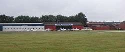
Breda International Airport
| Breda International Airport | |||||||||||
|---|---|---|---|---|---|---|---|---|---|---|---|
 | |||||||||||
| Summary | |||||||||||
| Airport type | Public | ||||||||||
| Operator | N.V. Vliegveld Seppe | ||||||||||
| Serves | Hoeven | ||||||||||
| Location | Bosschenhoofd (Seppe) | ||||||||||
| Elevation AMSL | 30 ft / 9 m | ||||||||||
| Coordinates | 51°33′17″N 004°33′09″E / 51.55472°N 4.55250°E | ||||||||||
| Website | www.breda-airport.eu | ||||||||||
| Runways | |||||||||||
| |||||||||||
Breda International Airport (Dutch: Breda International Airport (ICAO: EHSE)) is a small general aviation airfield located next to the A58 motorway on the outskirts of Bosschenhoofd, a village in the municipality of Halderberge in the province of North Brabant in the Netherlands. It is located 2 NM (3.7 km; 2.3 mi) southwest of Hoeven,[2] 7.5 NM (13.9 km; 8.6 mi) west from Breda and 4 NM (7.4 km; 4.6 mi) east-northeast of Roosendaal.[1]
The airport has one single asphalt runway, 07/25, with a length of 830 m (2,723 ft) and a significantly displaced threshold (meaning an area at the beginning of that runway is not to be used for landing) on either side.
Originally called Seppe Airport (after the nickname of Bosschenhoofd), the airport started in 1949 as a glider field and has been used by powered aircraft since 1969. In 2002, the runway surface was changed from grass to asphalt. The airfield is not to be used by aircraft using jet engines. Around 50,000 airplane movements (a movement being a take-off or a landing) are made at Seppe annually. In February 2014 it was announced that the name of the airport would be changed to Breda International Airport.[3] The airport was officially renamed on 01/01/2015.
The airfield is also home to a small flying museum, Vliegend Museum Seppe (The Flying Museum of Seppe), having various aircraft, most of which are still airworthy, such as two de Havilland Tiger Moths, a Boeing Stearman and a Yakovlev Yak-52.
The airfield additionally houses Aviation Performance Solutions, an aviation training company specializing in Upset Prevention and Recovery Training (UPRT).[4]
References
- 1 2 EHSE – HOEVEN/Seppe. AIP from AIS the Netherlands, effective 11 October 2018
- ↑ "Distance and heading from Hoeven (51°34'39"N 04°34'51"E) to EHSE (51°33'17"N 04°33'09"E)".
- ↑ Seppe Airport Website - Nieuw logo en naam Seppe Airport Archived April 13, 2015, at the Wayback Machine. (in Dutch), article retrieved 30 March 2014.
- ↑ Europe, APS. "Welcome to APS Europe, The Netherlands". TTC Seppe. TTC Seppe. Retrieved 23 July 2017.
| Wikimedia Commons has media related to Breda International Airport. |
External links
- Breda International Airport, official website
- Photos taken at Seppe Airport from Airliners.net
- Vliegend museum Seppe