Selway River
| Selway River | |
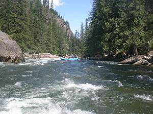 Selway River at the Goat Creek rapid | |
| Country | United States |
|---|---|
| State | Idaho |
| County | Idaho |
| Source | Southeast of Stripe Mountain |
| - location | Bitterroot National Forest, Selway-Bitterroot Wilderness, Bitterroot Mountains |
| - elevation | 6,857 ft (2,090 m) [1] |
| - coordinates | 45°29′49″N 114°44′37″W / 45.49694°N 114.74361°W [2] |
| Mouth | Meets Lochsa River to form Middle Fork Clearwater River |
| - location | Lowell, Nez Perce National Forest |
| - elevation | 1,453 ft (443 m) [2] |
| - coordinates | 46°08′25″N 115°35′58″W / 46.14028°N 115.59944°WCoordinates: 46°08′25″N 115°35′58″W / 46.14028°N 115.59944°W [2] |
| Length | 100 mi (161 km) [3] |
| Basin | 2,013 sq mi (5,214 km2) [4] |
 Course of the river | |
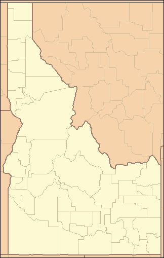 Location of the mouth of the Selway River in Idaho | |
| Wikimedia Commons: Selway River | |
| Type | Wild, Recreational |
| Designated | October 2, 1968 |
| Reference no. | P.L. 90-542 |
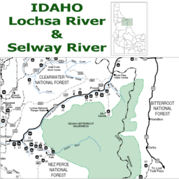
The Selway River is a large tributary of the Middle Fork of the Clearwater River in the U.S. state of Idaho. It flows within the Selway-Bitterroot Wilderness, the Bitterroot National Forest, and the Nez Perce National Forest of North Central Idaho.[5] The entire length of the Selway was included by the United States Congress in 1968 as part of the National Wild and Scenic Rivers Act.[6]
The main stem of the Selway is 100 miles (160 km) in length[3] from the headwaters in the Bitterroots to the confluence with the Lochsa near Lowell to form the Middle Fork of the Clearwater. The Selway River drains a 2,013-square-mile (5,210 km2) basin in Idaho County.[4]
History
The Selway River is home to Chinook salmon. Four salmon channels were built "in the mid-1960s by the Idaho Department of Fish and Game and by the Job Corps ... along the Selway to help re-establish the spring chinook run after hydroelectric dams were built downstream." The river was stocked with salmon eggs and fry "each fall through 1981, and again in 1985."[7] A 1993 book about the project, Indian Creek Chronicles, won the Pacific Northwest Booksellers Association Book Award.[8][9]
Flora
- Cedar - Western red cedar
- ferns
- Firs – Douglas and grand fir
- Huckleberries
- Pine - ponderosa pine
- Spruce - Engelmann spruce
Wildlife
- Birds
- Fish
- Trout – bullhead, bull, rainbow or steelhead and, westslope cutthroat trout
- Salmon- Chinook and coho
- Mountain whitefish
- Mammals
Recreation
- Backcountry skiing
- Camping
- Fly fishing – Limits and catch-and-release
- Hiking
- Whitewater rafting – permits required
See also
References
- ↑ Source elevation derived from Google Earth search using GNIS source coordinates.
- 1 2 3 "Selway River". Geographic Names Information System. United States Geological Survey. June 21, 1979. Retrieved January 25, 2013.
- 1 2 U.S. Geological Survey. "The National Map: National Hydrography Dataset High-Resolution Flowline Data". Retrieved May 3, 2011.
- 1 2 Bugosh, Nicholas (2000). "Lower Selway River Subbasin Assessment" (PDF). Lewiston, Idaho: Lewiston Regional Office, Idaho Division of Environmental Quality. Retrieved January 26, 2013.
- ↑ Idaho Atlas & Gazetteer (6th ed.). Yarmouth, Maine: DeLorme. 2007. pp. 52&ndash, 53, 55&ndash, 56. ISBN 978-0-89933-284-0.
- ↑ "Clearwater River (Middle Fork), Idaho". National Wild and Scenic Rivers System. Retrieved January 26, 2013.
- ↑ Briggeman, Kim (2011-06-12). "Students immersed in Magruder Corridor". Missoulian. Retrieved 2013-12-01.
- ↑ Fromm, Pete (2003). Indian Creek chronicles. New York: Picador. ISBN 0312422725.
- ↑ "Indian Creek Chronicles: A Winter Alone in the Wilderness by Pete Fromm". Barnes & Noble. Retrieved 2013-12-01.
Bibliography
- Floating the Wild Selway. (1991) [Missoula, Mont.?] : U.S. Dept. of Agriculture, Forest Service, Northern Region.
- Selway River Corridor: A Guide to Recreation on the Moose Creek Ranger District. (2000) Kooskia, Idaho : U.S. Dept. of Agriculture, Forest Service, Nez Perce National Forest, Moose Creek Ranger Station.
- Selway River fisheries investigations : job completion report. (1979) [Idaho] : Idaho Dept. of Fish & Game.
- A survey and evaluation of archaeological resources in the Magruder Corridor, Bitterroot National Forest, east-central Idaho, 1969. (1969) Pocatello, Idaho : Idaho State University Museum.
External links
| Wikimedia Commons has media related to Selway River. |