Seltinsky District
| Seltinsky District Селтинский район (Russian) Сьӧлта ёрос (Udmurt) | |
|---|---|
.svg.png) Location of Seltinsky District in the Udmurt Republic | |
| Coordinates: 57°21′04″N 51°43′34″E / 57.351°N 51.726°ECoordinates: 57°21′04″N 51°43′34″E / 57.351°N 51.726°E | |
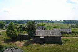 View of the selo of Valamaz in Seltinsky District | |
.png) |
 |
|
| |
| Location | |
| Country | Russia |
| Federal subject | Udmurt Republic[1] |
| Administrative structure (as of July 2012) | |
| Administrative center | selo of Selty[2] |
| Administrative divisions:[3] | |
| selsoviet | 9 |
| Inhabited localities:[3] | |
| Rural localities | 72 |
| Municipal structure (as of July 2005) | |
| Municipally incorporated as | Seltinsky Municipal District[4] |
| Municipal divisions:[4] | |
| Urban settlements | 0 |
| Rural settlements | 9 |
| Statistics | |
| Area | 1,883.7 km2 (727.3 sq mi)[5] |
| Population (2010 Census) | 11,368 inhabitants[6] |
| • Urban | 0% |
| • Rural | 100% |
| Density | 6.03/km2 (15.6/sq mi)[7] |
| Time zone | SAMT (UTC+04:00)[8] |
| Official website | |
| Seltinsky District on WikiCommons | |
Seltinsky District (Russian: Селти́нский райо́н; Udmurt: Сьӧлта ёрос) is an administrative[1] and municipal[4] district (raion), one of the twenty-five in the Udmurt Republic, Russia. It is located in the west of the republic. The area of the district is 1,883.7 square kilometers (727.3 sq mi).[5] Its administrative center is the rural locality (a selo) of Selty.[2] Population: 11,368 (2010 Census);[6] 13,335 (2002 Census);[9] 15,050 (1989 Census).[10] The population of Selty accounts for 46.4% of the district's total population.[6]
References
- 1 2 Constitution of the Udmurt Republic
- 1 2 Law #46-RZ
- 1 2 "General Information". Official District Website. Seltinsky District. Retrieved 28 August 2016.
- 1 2 3 Law #1-RZ
- 1 2 "Seltinsky" (in Russian). Federal State Statistics Service, Russian Federation. Retrieved August 27, 2016.
- 1 2 3 Russian Federal State Statistics Service (2011). "Всероссийская перепись населения 2010 года. Том 1" [2010 All-Russian Population Census, vol. 1]. Всероссийская перепись населения 2010 года (2010 All-Russia Population Census) (in Russian). Federal State Statistics Service. Retrieved June 29, 2012.
- ↑ The value of density was calculated automatically by dividing the 2010 Census population by the area specified in the infobox. Please note that this value is only approximate as the area specified in the infobox does not necessarily correspond to the area of the entity proper or is reported for the same year as the population.
- ↑ Правительство Российской Федерации. Федеральный закон №107-ФЗ от 3 июня 2011 г. «Об исчислении времени», в ред. Федерального закона №271-ФЗ от 03 июля 2016 г. «О внесении изменений в Федеральный закон "Об исчислении времени"». Вступил в силу по истечении шестидесяти дней после дня официального опубликования (6 августа 2011 г.). Опубликован: "Российская газета", №120, 6 июня 2011 г. (Government of the Russian Federation. Federal Law #107-FZ of June 31, 2011 On Calculating Time, as amended by the Federal Law #271-FZ of July 03, 2016 On Amending Federal Law "On Calculating Time". Effective as of after sixty days following the day of the official publication.).
- ↑ Russian Federal State Statistics Service (May 21, 2004). "Численность населения России, субъектов Российской Федерации в составе федеральных округов, районов, городских поселений, сельских населённых пунктов – районных центров и сельских населённых пунктов с населением 3 тысячи и более человек" [Population of Russia, Its Federal Districts, Federal Subjects, Districts, Urban Localities, Rural Localities—Administrative Centers, and Rural Localities with Population of Over 3,000] (XLS). Всероссийская перепись населения 2002 года [All-Russia Population Census of 2002] (in Russian). Retrieved August 9, 2014.
- ↑ Demoscope Weekly (1989). "Всесоюзная перепись населения 1989 г. Численность наличного населения союзных и автономных республик, автономных областей и округов, краёв, областей, районов, городских поселений и сёл-райцентров" [All Union Population Census of 1989: Present Population of Union and Autonomous Republics, Autonomous Oblasts and Okrugs, Krais, Oblasts, Districts, Urban Settlements, and Villages Serving as District Administrative Centers]. Всесоюзная перепись населения 1989 года [All-Union Population Census of 1989] (in Russian). Институт демографии Национального исследовательского университета: Высшая школа экономики [Institute of Demography at the National Research University: Higher School of Economics]. Retrieved August 9, 2014.
Sources
- Верховный Совет Удмуртской Республики. №663-XII 7 декабря 1994 г. «Конституция Удмуртской Республики», в ред. Закона №37-РЗ от 9 октября 2009 г «О внесении поправок к Конституции Удмуртской Республики». Опубликован: "Известия Удмуртской Республики", №№198-199, 27 декабря 1994 г. (Supreme Council of the Udmurt Republic. #663-XII December 7, 1994 Constitution of the Udmurt Republic, as amended by the Law #37-RZ of October 9, 2009 On Amending the Constitution of the Udmurt Republic. ).
- Государственный Совет Удмуртской Республики. Закон №1-РЗ от 28 января 2005 г. «Об установлении границ муниципальных образований и наделении соответствующим статусом муниципальных образований на территории Селтинского района Удмуртской Республики», в ред. Закона №39-РЗ от 12 июля 2005 г. «О внесении изменений в отдельные Законы Удмуртской Республики об установлении границ муниципальных образований и наделении соответствующим статусом муниципальных образований на территории Удмуртской Республики в связи с уточнением статуса и наименования отдельных населённых пунктов Удмуртской Республики». Вступил в силу с 1 января 2005 г. Опубликован: "Октябрь", №14, 25 февраля 2005 г. (State Council of the Udmurt Republic. Law #1-RZ of January 28, 2005 On Establishing the Borders of the Municipal Formations and Granting the Status to the Municipal Formations on the Territory of Seltinsky District of the Udmurt Republic, as amended by the Law #39-RZ of July 12, 2005 On Amending Various Laws of the Udmurt Republic on Establishing the Borders of the Municipal Formations and Granting the Status to the Municipal Formations on the Territory of the Udmurt Republic Due to Clarifications of Status and Names of Various Inhabited Localities in the Udmurt Republic. Effective as of January 1, 2005.).
- Государственный Совет Удмуртской Республики. Закон №46-РЗ от 19 октября 2006 г. «Об административно-территориальном устройстве Удмуртской Республики», в ред. Закона №60-РЗ от 12 октября 2012 г. «О внесении изменений в отдельные Законы Удмуртской Республики». Вступил в силу через десять дней после официального опубликования. Опубликован: "Известия Удмуртской Республики", №185, 12 декабря 2006 г. (State Council of the Udmurt Republic. Law #46-RZ of October 19, 2006 On the Administrative-Territorial Structure of the Udmurt Republic, as amended by the Law #60-RZ of October 12, 2012 On Amending Various Laws of the Udmurt Republic. Effective as of the day which is ten days after the official publication.).
| Administrative districts | |||
|---|---|---|---|
| Cities and towns | |||
This article is issued from
Wikipedia.
The text is licensed under Creative Commons - Attribution - Sharealike.
Additional terms may apply for the media files.