Segundo Frente
| Segundo Frente | |
|---|---|
| Municipality | |
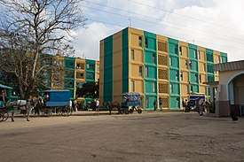 Apartment buildings in Mayarí Arriba | |
.png) Segundo Frente municipality (red) within Santiago Province (yellow) and Cuba | |
 Location of Segundo Frente in Cuba | |
| Coordinates: 20°24′43″N 75°31′43″W / 20.41194°N 75.52861°WCoordinates: 20°24′43″N 75°31′43″W / 20.41194°N 75.52861°W | |
| Country |
|
| Province | Santiago de Cuba |
| Seat | Mayarí Arriba |
| Area | |
| • Total | 540.2 km2 (208.6 sq mi) |
| Elevation | 180 m (590 ft) |
| Population (2005)[1] | |
| • Total | 40,885 |
| • Density | 75.7/km2 (196/sq mi) |
| Time zone | UTC-5 (EST) |
| Area code(s) | +53-226 |
Segundo Frente[1][2] (Spanish for "Second Front") is a municipality in the Santiago de Cuba Province of Cuba. Located in the northern part of the province, it is centered on the town, and municipal seat, of Mayarí Arriba.
Geography
The municipality is located north of the province, neighboring the provinces of Holguín and Guantánamo; and is partly included into Sierra Cristal National Park's territory. It borders with the municipalities of Mayarí, Frank País, Sagua de Tánamo, El Salvador, Songo-La Maya and San Luis. It counts the town of Mayarí Arriba and the villages of Boca de Micara, Loma Blanca, Sabanilla, San Benito de Mayarí, Soledad and Tumba Siete.[3]
Demographics
In 2004, the municipality of Segundo Frente had a population of 40,885.[1] With a total area of 540 km2 (210 sq mi), it has a population density of 75.7/km2 (196/sq mi).
See also
References
- 1 2 3 Santiago.cu (2006). "Municipalities of Santiago de Cuba" (in Spanish). Archived from the original on 2007-12-15. Retrieved 2007-10-05.
- ↑ (in Spanish) Segundo Frente (article on EcuRed)
- ↑ 5919054 Segundo Frente on OpenStreetMap
External links
![]()
- (in Spanish) Segundo Frente on EcuRed