Segobriga
 | |
 Shown within Spain | |
| Location | Spain |
|---|---|
| Region | Castile–La Mancha |
| Coordinates | 39°53′06″N 2°48′47″W / 39.885°N 2.813°W |
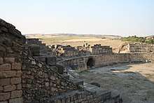
Segóbriga was an important Celtic and Roman city, and is today an impressive site located on a hill near the present town of Saelices. Archaeology has revealed the remains of important buildings which have been conserved and are visible today in the Archaeological Park. Bien de Interés Cultural declared National Monument on June 3, 1931.[1][2]
Although the city is in ruins, its state of conservation is more than acceptable, compared to other remains located on the peninsula. Your visit provides an idea of how everyday life developed in a city of antiquity.
Toponymy
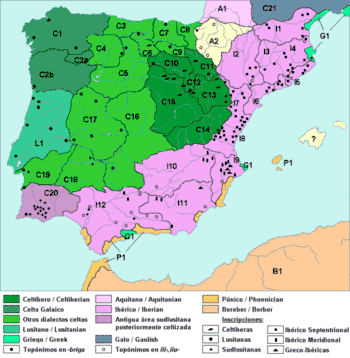
The name of Segóbriga derives from two terms of Celtiberian origin, language of the Indo-European Celtic branch. The toponym would come from the term Sego-, which would mean victory (prefix also present in the name of the cities of Segovia, Segorbe, Segeda and Segontia), and of the suffix -briga, which would mean city, strength. For what its translation would come to be "City of the victory" or "Victorious city". The term -briga is very common in the place names of the Celtiberian region or expansion of the Celtic languages in the Iberian Peninsula.
History

In the year 1888 was found a collective sepulcher (II millennium BC) of the Bronze Age (celtiberian settlement) in the Cueva de Segóbriga, excavated in limestone and found near the Cerro de Cabeza de Griego. This finding was published in the year 1893. In the place appeared both human remains and everyday supplies.
It can be conjectured that initially it would be a celtiberian castro that dominated the basin located north of the city, being defended by the Cigüela river, which served as a moat. Its remains have not appeared, but a fragment of Attica ceramics of 5th century BC testifies to its occupation from that early date.
The first mention we have of Segóbriga is a brief reference by the Greek geographer Strabo,[3] that Quintus Caecilius Metellus Pius fought in the Wars of Sertorius, in the Celtiberian region around Bílbilis and Segóbriga. This ancient area of the Olcade tribe was thus razed in these wars and replaced by Roman Segóbriga.
From some texts of the 3rd and 2nd centuries BC is called Olcades the inhabitants of that area towards the Serranía de Cuenca, towards the Alcarria and province of Guadalajara they are called Lusones, and toward Toledo, Carpetani. Therefore, the inhabitants of the area and the old city would be Olcades or Carpetani. At 7 km there is the site of Villas Viejas, identified with the Contrebia Carbica, city of Carpetani.[4]
Writing in the first century BC, Sextus Julius Frontinus mentions Segóbriga twice.[5] He describes the attack by the Lusitanian Viriatus against Segóbriga (146 BC) which was allied to Rome:
1) "Viriatus, arranging his troops in ambush, sent a few to steal cattle from the Segobrigenses; they like to go in large numbers to punish, they ran, fleeing ..."
2) "Viriatus turned back and ran into unsuspecting Segobrigenses, when most were busy at their sacrifice".
Pliny[6] mentions the exploitation of lapis specularis, a variety of translucent gypsum much appreciated at the time for the manufacture of window glass and an important part of the Segbriga economy. This material was mined in "100,000 places around Segóbriga" and Pliny assures us that "the most translucent of this stone is obtained near the city of Segóbriga and extracted from deep wells".
Pliny the Elder in his Naturalis Historia, in section 24, lists the towns belonging to the Caesaraugustan Juridical Convent, among which they appear the Ercavicenses (of the city of Ercavica, neighbors of the Segobrigans). Later, in section 27, it defines Segóbriga and its area as caput Celtiberiae ('head of Celtiberia'), which reached to Clunia (finis celtiberiae), following a geographical order from the South to the North, which suggests, together with the previous data, that the Segóbriga zone was the boundary between the Celtiberians and the Carpetanis. It also indicates that Segóbriga was a stipendiary (tributary) city of that Conventus.
Later, in section 36 of his Naturalis Historia Pliny mentions the exploitation of lapis specularis,[7][8] a variety of translucent specular gypsum that was very popular at the time for the manufacture of window glass and that would be for a long time an important part of Segóbriga's economy. This mineral was extracted from mines found in "100,000 steps around Segóbriga," and Pliny assures us that "the most translucent of this stone is obtained in the Hispania Citerior, near the city of Segóbriga and extracted of deep wells. One of these mines can be found in the nearby village of Carrascosa del Campo, which also had a manufacturing and mining enclave in service in this municipality.

After its Roman conquest at the beginning of 2nd BC, in the Celtiberian Wars, Segóbriga had to become an oppidum or Celtiberian city.[9] After the wars of Sertorius, among 80s and 72 BC, became the center of all that part of the Meseta Central, with the control of a large territory.
In the time of Augustus, around year 12 BC, ceased to be a stipendiary city, which paid tribute to Rome, and became municipium, city ruled by Roman citizens, increasing the status of the city notably, which led to its economic boom and a large program of monumental constructions that must have ended in flavian epoch, towards 80, to which public leisure buildings and the wall that can be admired today. The city was an important communications center. From this time is also the issue of currency in its mint and the construction of a part of the wall. At the end of the mandate of Vespasian the city was at its highest point, having completed the works of the theater and amphitheater, and being fully integrated socially and economically in the Roman Empire.
Archaeological findings indicate that in the 3rd century there still existed in Segóbriga important elites who lived in the city, but in the 4th century are already abandoned their main monuments, proof of its inexorable decline and its progressive conversion in a rural center.
At the Visigoth time, as of 5th century, it still had to be an important city, since remains of several basilicas and an extensive necropolis are known (according to findings of 1760 - 1790), its bishops arriving to attend various Councils of Toledo, specifically to the Third Council of Toledo in year 589, and the Sixteenth Council of Toledo in 693.
Its definitive depopulation had to begin after the Muslim invasion of the Iberian Peninsula, when its bishops and governing elites fled towards the north, looking for the shelter of the Christian kingdoms, as it is known that it happened in the neighboring city of Ercavica (Cañaveruelas, Province of Cuenca). From these dates are the remains of a Muslim fortification that occupies the summit of the hill.
After the Reconquista, the population of the contours moved to the current town of Saelices, located 3 km further north, next to the fountain that nourished the aqueduct that had supplied the ancient city of Segóbriga. Forgotten and to its name, the hill that it occupied happened to be denominated "Cabeza del Griego", with a small rural population dependent on the town of Uclés, located to only 10 km, coming to use ashlars extracted of the ruins for the construction of its convent-fortress.
Since then its gradual abandonment was accentuated until only the small hermitage built on the ancient Monumental Baths remained, the last testimony of the ancient city preserved until the present time.
Conservation
The landscape of the Archaeological Park of Segóbriga is threatened by the upcoming construction of a wind farm nearby, promoted by the company Energías Eólicas de Cuenca. The deposit will be altered with the installation of 14 wind turbines of 121 meters in height that will also affect the Historic Site of Uclés.[10] This fact has led to the entrance of the Segóbriga Archaeological Park, together with the Historical Site of Uclés in the Red list of endangered heritage of the association for the defense of heritage Hispania Nostra.[11]
Current Segóbriga constructions


Celtiberians
- The necropolis (outside walls).
Romans
- The wall and the North Gate
- Amphitheater of Segóbriga
- Theater
- The Monumental Thermaes
- the theater's gym and thermaes
- Forum
- The Acropolis
- The rock sanctuary of Diana (outside walls)
- The aqueduct (outside walls)
- The quarries (outside walls)
- The circus (outside walls): The most recent investigations have determined that this construction was built on a necropolis, but that it never came to an end.
Visigoths
- The basilica of Cabeza de Griego (outside walls)
See also
References

- ↑ Ministry of Public Instruction and Fine Arts. Decree declaring Historic-Artistic monuments, belonging to the National Artistic Treasure. Gaceta de Madrid. 06/04/1931; (155): 1181-5.
- ↑ Resolution of 23 October 2001, of the Directorate General of Cultural Assets and Activities of the Ministry of Education and Culture, which initiates a file to declare the Archaeological Park of Segóbriga, located in Saelices and Almonacid del Marquesado, province of Cuenca. BOE. 12/12/2001; (297): 46.808-9.
- ↑ Strabo: The Geography
- ↑ Martín Almagro -Gorbea and Juan Manuel Abascal (1999). Segóbriga y su conjunto arqueológico. Real Academia de la Historia and Community Board of Castile-La Mancha.
- ↑ Frontinus: Strategemata
- ↑ Naturalis Historia
- ↑ Pliny, NH, XXXVI, 160: Et hi quidem sectiles sunt, specularis vero, quoniam et hic lapidis nomen optinet, faciliore multo natura finditur in quamlibeat tenues crustas. Hispania hunc tantum citerior olim dabat, nec tota, sed intra CM passuum circa Segobrigam urbem
- ↑ Translation: The stones described above are allowed to cut with the saw; but the specular stone, because it also receives the name of stone, given its much more treatable constitution, is split and separated into thin sheets as desired. Formerly it was only in the Hispania Citerior, and not in the whole province, but only in the area of one hundred thousand steps around the city of Segóbriga
- ↑ The Celtiberian Capital Pliny the Elder Hª Naturalis book III - 25
- ↑ El tesoro de Segóbriga, recuerdos del esplendor romano en tierras de Cuenca, 20 minutes (November 17, 2016).
- ↑ Hispania Nostra. "Historic Site of Uclés and Archaeological Park of Segóbriga".
| Croatia |  | |
|---|---|---|
| France | ||
| Germany | ||
| Italy | ||
| Jordan | ||
| Luxembourg | ||
| Spain |
| |
| Turkey | ||
| Wales | ||