Seegebiet Mansfelder Land
| Seegebiet Mansfelder Land | |
|---|---|
 Seegebiet Mansfelder Land Location of Seegebiet Mansfelder Land within Mansfeld-Südharz district 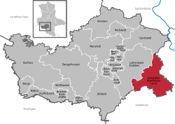 | |
| Coordinates: 51°28′N 11°41′E / 51.467°N 11.683°ECoordinates: 51°28′N 11°41′E / 51.467°N 11.683°E | |
| Country | Germany |
| State | Saxony-Anhalt |
| District | Mansfeld-Südharz |
| Government | |
| • Mayor | Jürgen Ludwig |
| Area | |
| • Total | 107.92 km2 (41.67 sq mi) |
| Elevation | 95 m (312 ft) |
| Population (2017-12-31)[1] | |
| • Total | 9,065 |
| • Density | 84/km2 (220/sq mi) |
| Time zone | CET/CEST (UTC+1/+2) |
| Postal codes | 06317, 06295 |
| Dialling codes | 034776, 034774, 034601 (Amsdorf, Wansleben am See), 034773 (Dederstedt, Neehausen), 03475 (Lüttchendorf, Neehausen) |
| Vehicle registration | MSH, EIL, HET, ML, SGH |
Seegebiet Mansfelder Land is a municipality in the Mansfeld-Südharz district, Saxony-Anhalt, Germany. It was formed on 1 January 2010 by the merger of the former municipalities Amsdorf, Aseleben, Erdeborn, Hornburg, Lüttchendorf, Neehausen, Röblingen am See, Seeburg, Stedten and Wansleben am See.
Towns and municipalities in the district of Mansfeld-Südharz | ||
|---|---|---|
References
This article is issued from
Wikipedia.
The text is licensed under Creative Commons - Attribution - Sharealike.
Additional terms may apply for the media files.