Scribner Covered Bridge
| Scribner Covered Bridge | |
|---|---|
 Bridge in U.S. state of Vermont | |
| Coordinates | 44°38′17″N 72°38′53″W / 44.638°N 72.648°WCoordinates: 44°38′17″N 72°38′53″W / 44.638°N 72.648°W |
| Carries | Automobile |
| Crosses | Gihon River |
| Locale | Johnson, Vermont |
| Maintained by | Town of Johnson |
| ID number | VT-08-09 |
| Characteristics | |
| Design | Covered, Queen post |
| Material | Wood |
| Total length | 47.8 ft (14.57 m) |
| Width | 12.4 ft (3.78 m) |
| No. of spans | 1 |
| Load limit | 8 tons |
| Clearance above | 8.25 ft (2.51 m) |
| History | |
| Constructed by | unknown |
| Construction end |
unknown |
|
Scribner Covered Bridge | |
  | |
| Coordinates | 44°38′17″N 72°38′53″W / 44.63806°N 72.64806°WCoordinates: 44°38′17″N 72°38′53″W / 44.63806°N 72.64806°W |
| Area | 1 acre (0.40 ha) |
| NRHP reference # | 74000233[1] |
| Added to NRHP | October 1, 1974 |
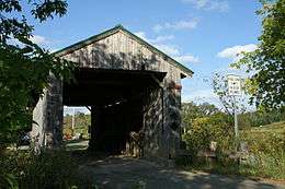
The Scribner Covered Bridge, also known as the Mudgett Covered Bridge,[2] is a covered bridge that carries Rocky Road across the Gihon River off State Route 100C in eastern Johnson, Vermont. It was listed on the National Register of Historic Places in 1974.[1] It is one of a small number of Vermont's covered bridges that are the result of covering and existing open bridge.
Description and history
The Scribner Covered Bridge stands in a rural area of eastern Johnson, carrying Rocky Road across the Gihon River between Vermont Route 100C and Sinclair Road. It is a single-span queen post truss, 48 feet (15 m) long and 17.5 feet (5.3 m) wide, with a roadway width of 13.5 feet (4.1 m) (one lane). It is covered by a gabled metal roof, and its exterior is clad in vertical board siding, which extends around to the insides of the portals. On the sides, the siding ends short of the roof, leaving an open strip. The bridge rests on concrete abutments that date to 1960. The trusses are unusually short and lack internal bracing, and their corner joints have been reinforced with metal plates.[3]
The bridge's construction date and builder are not known. It has been determined that the bridge was originally an uncovered Pony truss bridge, due to the relatively low height of the queen post trusses and the discovery of supporting documents.[4] In 1960, minor repairs were carried out and steel I beams were installed underneath the road deck.[4]
See also
References
- 1 2 National Park Service (2010-07-09). "National Register Information System". National Register of Historic Places. National Park Service.
- ↑ U.S. Geological Survey Geographic Names Information System: Scribner Covered Bridge
- ↑ Hugh Henry (1974). "NRHP nomination for Scribner Covered Bridge". National Park Service. Retrieved 2016-12-27. with photos from 1974
- 1 2 Barna, Ed. Covered Bridges of Vermont. The Countryman Press, 1996. ISBN 0-88150-373-8