Scranton, Iowa
| Scranton, Iowa | |
|---|---|
| City | |
 | |
 Location of Scranton, Iowa | |
| Coordinates: 42°1′20″N 94°32′46″W / 42.02222°N 94.54611°WCoordinates: 42°1′20″N 94°32′46″W / 42.02222°N 94.54611°W | |
| Country |
|
| State |
|
| County | Greene |
| Area[1] | |
| • Total | 1.88 sq mi (4.87 km2) |
| • Land | 1.88 sq mi (4.87 km2) |
| • Water | 0 sq mi (0 km2) |
| Elevation | 1,178 ft (359 m) |
| Population (2010)[2] | |
| • Total | 557 |
| • Estimate (2016)[3] | 532 |
| • Density | 296/sq mi (114.4/km2) |
| Time zone | UTC-6 (Central (CST)) |
| • Summer (DST) | UTC-5 (CDT) |
| ZIP code | 51462 |
| Area code(s) | 712 |
| FIPS code | 19-71310 |
| GNIS feature ID | 0461492 |
| Website | www.scrantoniowa.com |
Scranton is a city in Greene County, Iowa, United States. The population was 557 at the 2010 census. It was also named after Scranton, Pennsylvania.
History
Scranton was platted in 1869, shortly after the Cedar Rapids & Missouri River Railroad was built through that territory.[4] It was named for Joseph H. Scranton from Scranton, Pennsylvania.[5] Scranton was incorporated in 1880.[4]
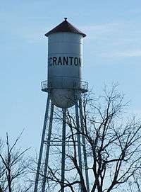
Scranton's water tower, built in 1897, is the oldest working water tower in Iowa and 9th oldest in the United States. A fire occurred at the tower in 1907, initially started to melt ice that had caused the town to be without water. Three men were injured attempting to put the fire out, although the tower itself did not suffer any major damage.[6]
Geography
Scranton is located along U.S. Route 30 at 42°1′20″N 94°32′46″W / 42.02222°N 94.54611°W (42.022197, -94.546047),[7] in the valley of the North Raccoon River.
According to the United States Census Bureau, the city has a total area of 1.88 square miles (4.87 km2), all of it land.[1]
Demographics
| Historical populations | ||
|---|---|---|
| Year | Pop. | ±% |
| 1890 | 715 | — |
| 1900 | 983 | +37.5% |
| 1910 | 845 | −14.0% |
| 1920 | 843 | −0.2% |
| 1930 | 1,058 | +25.5% |
| 1940 | 1,014 | −4.2% |
| 1950 | 891 | −12.1% |
| 1960 | 865 | −2.9% |
| 1970 | 751 | −13.2% |
| 1980 | 748 | −0.4% |
| 1990 | 583 | −22.1% |
| 2000 | 604 | +3.6% |
| 2010 | 557 | −7.8% |
| 2016 | 532 | −4.5% |
| Source:"American FactFinder". United States Census Bureau.
and Iowa Data Center Source: | ||
2010 census
As of the census[2] of 2010, there were 557 people, 238 households, and 143 families residing in the city. The population density was 296.3 inhabitants per square mile (114.4/km2). There were 267 housing units at an average density of 142.0 per square mile (54.8/km2). The racial makeup of the city was 96.4% White, 0.2% Pacific Islander, 2.7% from other races, and 0.7% from two or more races. Hispanic or Latino of any race were 2.9% of the population.
There were 238 households of which 26.5% had children under the age of 18 living with them, 50.8% were married couples living together, 5.0% had a female householder with no husband present, 4.2% had a male householder with no wife present, and 39.9% were non-families. 34.5% of all households were made up of individuals and 12.2% had someone living alone who was 65 years of age or older. The average household size was 2.34 and the average family size was 3.06.
The median age in the city was 43.2 years. 23.2% of residents were under the age of 18; 6.7% were between the ages of 18 and 24; 22.2% were from 25 to 44; 27.7% were from 45 to 64; and 20.1% were 65 years of age or older. The gender makeup of the city was 51.2% male and 48.8% female.
2000 census
As of the census[9] of 2000, there were 604 people, 258 households, and 157 families residing in the city. The population density was 321.6 people per square mile (124.0/km²). There were 285 housing units at an average density of 151.8 per square mile (58.5/km²). The racial makeup of the city was 96.52% White, 0.17% Asian, 2.65% from other races, and 0.66% from two or more races. Hispanic or Latino of any race were 5.13% of the population.
There were 258 households out of which 28.7% had children under the age of 18 living with them, 50.0% were married couples living together, 7.8% had a female householder with no husband present, and 38.8% were non-families. 34.9% of all households were made up of individuals and 17.8% had someone living alone who was 65 years of age or older. The average household size was 2.34 and the average family size was 3.05.
In the city, the population was spread out with 26.5% under the age of 18, 7.8% from 18 to 24, 22.4% from 25 to 44, 24.2% from 45 to 64, and 19.2% who were 65 years of age or older. The median age was 39 years. For every 100 females, there were 93.6 males. For every 100 females age 18 and over, there were 90.6 males.
As of 2000 the median income for a household was $29,375, and the median income for a family was $38,542. Males had a median income of $27,411 versus $17,188 for females. The per capita income for the city was $13,836. About 10.6% of families and 13.1% of the population were below the poverty line, including 13.8% of those under age 18 and 9.1% of those age 65 or over.
Education
Residents are in the Greene County Community School District,[10] which operates Greene County Elementary, Greene County Middle, and Greene County High schools in Jefferson.[11] It was a part of the Jefferson-Scranton Community School District until it merged into the Greene County district on July 1, 2014.[12]
Scranton formerly had a public school building of its own, which had a three-story section built in 1915. The school closed in 2008; the school district had notified the city government in 2006 so the city could plan for the future of the school. In 2010 the city government acquired the building, paying $1 for it, and converted it into a community center; the city government considered converting the school facility into an apartment block, but it determined it would have required too much money. The city government determined that it could not find a purpose for the 1913 section; therefore its razing occurred in 2012. The current Greene County district, as of 2014, rented the school gymnasium for athletic meetups.[13]
Community
Annual events in Scranton include the Mid-Summer Festival, held in July, and a Christmas celebration.
Every 5 years the town holds an all school reunion. Next reunion will be in 2015.
Three churches exist in Scranton; St. Paul's Catholic Church, the United Methodist Church and the Church of Christ.[6]
Notable residents
- Bryce Paup, NFL football player
- Ruth Jackson (1902 – 1994), the first female board-certified orthopedic surgeon in the United States, was born on a farm near Scranton.
References
- 1 2 "US Gazetteer files 2010". United States Census Bureau. Archived from the original on 2012-01-24. Retrieved 2012-05-11.
- 1 2 "American FactFinder". United States Census Bureau. Retrieved 2012-05-11.
- ↑ "Population and Housing Unit Estimates". Retrieved June 9, 2017.
- 1 2 Stillman, Edwin B. (1907). Past and Present of Greene County, Iowa. Brookhaven Press. pp. 165–166.
- ↑ Chicago and North Western Railway Company (1908). A History of the Origin of the Place Names Connected with the Chicago & North Western and Chicago, St. Paul, Minneapolis & Omaha Railways. p. 123.
- 1 2 "Communities of Greene County - Scranton". Greene County Development Corp. Retrieved 2009-01-18.
- ↑ "US Gazetteer files: 2010, 2000, and 1990". United States Census Bureau. 2011-02-12. Retrieved 2011-04-23.
- ↑ "Census of Population and Housing". Census.gov. Retrieved June 4, 2015.
- ↑ "American FactFinder". United States Census Bureau. Retrieved 2008-01-31.
- ↑ "Greene County." Iowa Department of Education. Retrieved on June 25, 2018.
- ↑ Home. Greene County Community School District. Retrieved on July 18, 2018.
- ↑ "East Greene and Jefferson-Scranton schools vote to consolidate". Daily Times-Herald. 2013-02-06. Retrieved 2018-06-25.
- ↑ "When schools close". Daily Times Herald. 2014-03-28. Retrieved 2018-07-17.
| Wikimedia Commons has media related to Scranton, Iowa. |
Municipalities and communities of Greene County, Iowa, United States | ||
|---|---|---|
| Cities | ||
| Townships | ||
| Unincorporated communities | ||
| Footnotes | ‡This populated place also has portions in an adjacent county or counties | |