Schwieberdingen
| Schwieberdingen | ||
|---|---|---|
 | ||
| ||
 Schwieberdingen Location in Ludwigsburg district 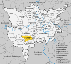 | ||
| Coordinates: 48°52′40″N 9°4′30″E / 48.87778°N 9.07500°ECoordinates: 48°52′40″N 9°4′30″E / 48.87778°N 9.07500°E | ||
| Country | Germany | |
| State | Baden-Württemberg | |
| Admin. region | Stuttgart | |
| District | Ludwigsburg | |
| Government | ||
| • Mayor | Nico Lauxmann | |
| Area | ||
| • Total | 14.87 km2 (5.74 sq mi) | |
| Elevation | 274 m (899 ft) | |
| Population (2017-12-31)[1] | ||
| • Total | 11,406 | |
| • Density | 770/km2 (2,000/sq mi) | |
| Time zone | CET/CEST (UTC+1/+2) | |
| Postal codes | 71701 | |
| Dialling codes | 07150 | |
| Vehicle registration | LB | |
| Website | www.schwieberdingen.de | |

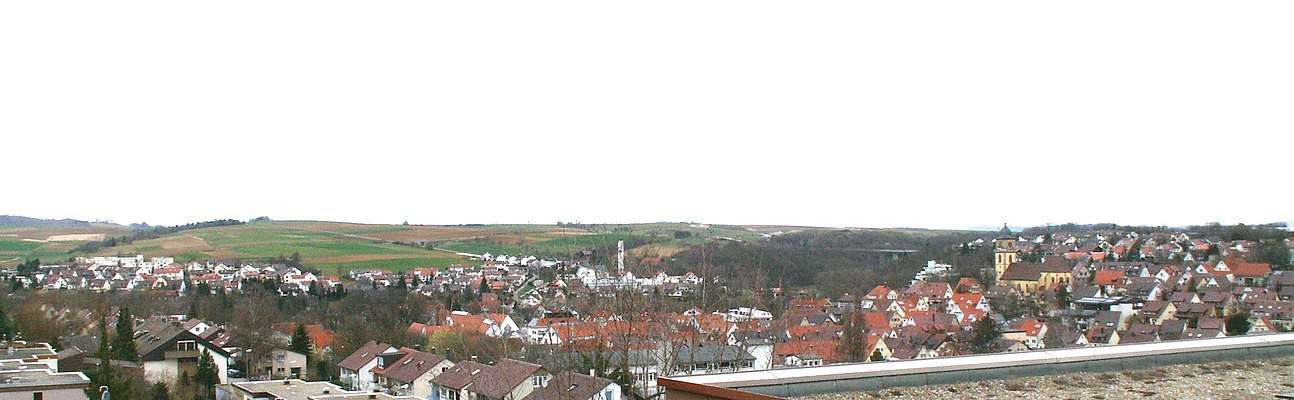
Schwieberdingen is a municipality of the Ludwigsburg district in Baden-Württemberg, Germany. The town itself is located about 10 kilometers (6.2 mi) from Stuttgart, the state capital, and 5 kilometers (3.1 mi) from Ludwigsburg, the district capital. Schwieberdingen belongs to the Stuttgart Region and Metropolitan Region. Schwieberdingen is twinned with the French township of Vaux-le-Pénil.
Schwieberdingen was possibly founded in the 3rd century, but was first mentioned in a 1304 document. The town is characterized by its location on the route from Flanders to the Black Sea, which today forms the Bundesstraße 10. After the Second World War, Schwieberdingen transitioned from an agricultural base to an industrial one.
The town's sports club is the TSV Schwieberdingen. Its largest division, the football club, plays in the Verbandsliga Württemberg.
Geography

Schwieberdingen is located in the southwest part of the Neckar basin, in the center of the German state of Baden-Württemberg.
The landscape around Schwieberdingen shows a great diversity of soil formations, visible in the suffixes -berg, -grund, and -tal within the municipality. The river Glems, which flows through Schwieberdingen itself, periodically floods the surrounding Langes Feld and Strohgäu.
The highest point above sea level in Schwieberdingen is the Katharinenlinde at 351 meters (1,152 ft) NN, and the lowest is the Gemarkungsgrenze at 238 meters (781 ft) NN.
Climate
Schwieberdingen is characterized by a mild climate caused by its location in the southwest region of the Neckar basin. It is shielded by the Black Forest to the west, the Swabian Alb to the south, the Swabian-Franconian Forest to the east, and the Stromberg-Heuchelberg to the northwest. Belonging to the Upper Rhine Valley and the Stuttgart Metropolitan Region, Schwieberdingen is in one of the warmest areas of Germany. The warmest month is July, with a mean temperature of 18.8 °C (65.8 °F), while the coldest is January with an average temperature of 1.3 °C (34.3 °F). The average annual rainfall in Schwieberdingen is 679 millimeters (26.7 in), coming mostly between June and August as is normal in southern Germany. Low rainfall in the region has led to the necessity of external water supply, found in the Lake Constance Water Supply project from 1954 onward.
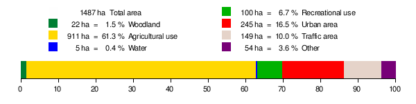
Area distribution
According to the Baden-Württemberg State Statistical Office, the municipality of Schwieberdingen comprises 1,487 hectares (3,670 acres) total, as of 2014. Agriculture takes up most of the municipality area at 61.3%, while the rest of the municipality is urban environment or woodland.[2]
History
The first traces of habitation in Schwieberdingen come from about 5000 BC, in the Neolithic period. The State Office for Monument Preservation has discovered two Neolithic settlements in Schwieberdingen. The first belonged to what has been called the Schwieberdinger culture and is date to 4300 BC to 4200 BC and includes the skeleton of a woman dated to 4000 BC. The second settlement belonged to the Michelsberg culture and is about 700 to 800 years newer than the Schwieberdinger culture.
Roman and Migration periods
In 85 AD, the Roman Empire conquered the Celtic tribes in the area and then constructed a road over the Glems ford. This road shaped Schwieberdingen's town plan for centuries and was primarily used by the Roman military. Roman farming estates are also present in the area.
References
- ↑ "Bevölkerung nach Nationalität und Geschlecht am 31. Dezember 2017". Statistisches Landesamt Baden-Württemberg (in German). 2018.
- ↑ "Fläche seit 1996 nach tatsächlicher Nutzung". statistik-bw.de (in German). Baden-Württemberg State Statistical Office. Retrieved 18 September 2018.