Schwarzwasser (Mulde)
| Schwarzwasser | |
|---|---|
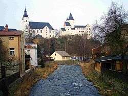 The Schwarzwasser in Schwarzenberg | |
| Location |
|
| Physical characteristics | |
| Main source |
on the Fichtelberg ca. 1,117 m above sea level (NHN) 50°25′08″N 12°56′16″E / 50.4188194°N 12.9377083°E |
| River mouth |
in Aue into the Zwickauer Mulde 342.3 m above sea level (NHN) 50°35′19″N 12°42′07″E / 50.5886806°N 12.702083°ECoordinates: 50°35′19″N 12°42′07″E / 50.5886806°N 12.702083°E |
| Discharge | |
| Basin features | |
| Progression | Zwickauer Mulde→ Mulde→ Elbe→ North Sea |
| Tributaries |
|
| Waterbodies | Reservoirs: Myslivny Reservoir |
The Schwarzwasser (Czech: Černá) is a right tributary of the Zwickauer Mulde in the German state of Saxony and the Czech Republic. It flows through Schwarzenberg.
Gallery
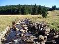 The Schwarzwasser near Luhy
 The Schwarzwasser above Potůčky
 Aue: mouth of the Schwarzwasser (left) at the Mulde
References
- 1 2 3 Hochwasserschutz 2002 im Muldegebiet Sächsisches Landesamt für Umwelt, Landwirtschaft und Geologie; 2009 (pdf)
Sources
- Jörg Brückner u.a.: Das Schwarzwassertal vom Fichtelberg zur Zwickauer Mulde in historischen Ansichten, Horb am Neckar 1993.
External links

This article is issued from
Wikipedia.
The text is licensed under Creative Commons - Attribution - Sharealike.
Additional terms may apply for the media files.