Schnaittach
| Schnaittach | ||
|---|---|---|
 | ||
| ||
 Schnaittach Location of Schnaittach within Nürnberger Land district 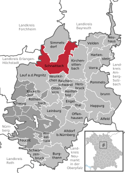 | ||
| Coordinates: 49°33′33″N 11°20′35″E / 49.55917°N 11.34306°ECoordinates: 49°33′33″N 11°20′35″E / 49.55917°N 11.34306°E | ||
| Country | Germany | |
| State | Bavaria | |
| Admin. region | Mittelfranken | |
| District | Nürnberger Land | |
| Government | ||
| • Mayor | Frank Pitterlein (CSU) | |
| Area | ||
| • Total | 49.36 km2 (19.06 sq mi) | |
| Elevation | 355 m (1,165 ft) | |
| Population (2017-12-31)[1] | ||
| • Total | 8,329 | |
| • Density | 170/km2 (440/sq mi) | |
| Time zone | CET/CEST (UTC+1/+2) | |
| Postal codes | 91220 | |
| Dialling codes | 09153 | |
| Vehicle registration | LAU, ESB, HEB, N, PEG | |
| Website | www.schnaittach.de | |

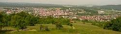
Schnaittach is a market town in Middle Franconia, Bavaria, Germany.
Geography
Geographical location
Schnaittach is on the river of the same name, a tributary of the Pegnitz.
History
Schnaittach was first mentioned in 1011.
Religions
Until 1806 the Christian population of Schnaittach was Catholic, in contrast to the surrounding areas. Schnaittach has had a large Jewish community since the 15th century. Today, the building complex of the synagogue houses a branch of the Jewish Museum of Franconia (the main museum is in Fürth).
Twin towns
- Twinned with Frohnleiten, Austria
- "Friendship" with Schlettau
References
- ↑ "Fortschreibung des Bevölkerungsstandes". Bayerisches Landesamt für Statistik und Datenverarbeitung (in German). September 2018.
External links
- Official town Web site (in German)
- Fortifications near Schnaittach (in German)
- Jewish Museum of Franconia (in German)
This article is issued from
Wikipedia.
The text is licensed under Creative Commons - Attribution - Sharealike.
Additional terms may apply for the media files.