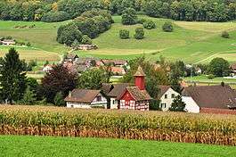
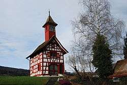
Schleinikon
| Schleinikon | ||
|---|---|---|
 | ||
| ||
 Schleinikon | ||
|
Location of Schleinikon 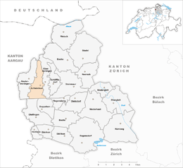 Schleinikon Schleinikon (Canton of Zurich) | ||
| Coordinates: 47°30′N 8°24′E / 47.500°N 8.400°ECoordinates: 47°30′N 8°24′E / 47.500°N 8.400°E | ||
| Country | Switzerland | |
| Canton | Zurich | |
| District | Dielsdorf | |
| Area[1] | ||
| • Total | 5.68 km2 (2.19 sq mi) | |
| Elevation | 472 m (1,549 ft) | |
| Population (Dec 2017[2]) | ||
| • Total | 736 | |
| • Density | 130/km2 (340/sq mi) | |
| Postal code | 8165 | |
| SFOS number | 0098 | |
| Surrounded by | Boppelsen, Niederweningen, Oberweningen, Otelfingen, Regensberg, Siglistorf (AG) | |
| Website |
http://www.schleinikon.ch SFSO statistics | |

Schleinikon is a municipality in the district of Dielsdorf in the canton of Zürich in Switzerland.
Geography
Situated in the Wehntal, Schleinikon has an area of 5.7 km2 (2.2 sq mi). Of this area, 49.9% is used for agricultural purposes, while 43.2% is forested. Of the rest of the land, 6.7% is settled (buildings or roads) and the remainder (0.2%) is non-productive (rivers, glaciers or mountains).[3]
Demographics
Schleinikon has a population (as of 31 December 2017) of 736.[2] As of 2007, 5.7% of the population was made up of foreign nationals. Over the last 10 years the population has grown at a rate of 9.4%. Most of the population (as of 2000) speaks German (95.8%), with English being second most common ( 0.6%) and Serbo-Croatian being third ( 0.6%).
In the 2007 election the most popular party was the SVP which received 39.8% of the vote. The next three most popular parties were the SPS (18.3%), the CSP (12.9%) and the Green Party (11.4%).
The age distribution of the population (as of 2000) is children and teenagers (0–19 years old) make up 27% of the population, while adults (20–64 years old) make up 63% and seniors (over 64 years old) make up 10%. In Schleinikon about 84% of the population (between age 25-64) have completed either non-mandatory upper secondary education or additional higher education (either university or a Fachhochschule).
Schleinikon has an unemployment rate of 0.92%. As of 2005, there were 45 people employed in the primary economic sector and about 18 businesses involved in this sector. 24 people are employed in the secondary sector and there are 6 businesses in this sector. 34 people are employed in the tertiary sector, with 13 businesses in this sector.[3]
References
- ↑ Arealstatistik Standard - Gemeindedaten nach 4 Hauptbereichen
- 1 2 Swiss Federal Statistical Office - STAT-TAB, online database – Ständige und nichtständige Wohnbevölkerung nach institutionellen Gliederungen, Geburtsort und Staatsangehörigkeit (in German) accessed 17 September 2018
- 1 2 Swiss Federal Statistical Office accessed 04-Aug-2009
| Wikimedia Commons has media related to Schleinikon. |