Scharhörnbake
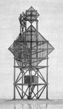
The Scharhörnbake was the most important daymark on the German north sea coast for a long time. First erected in 1661 by the City of Hamburg on the sandbank Scharhörn and south side of the Elbe estuary, it was rebuilt over centuries and taken down finally in 1979. Equipped with a room, it also functioned as a refuge beacon for shipwreck survivors from 1840 to 1965.[1][2][3] The only remains today is the boulder stone foundation near Nigehörn.
With height of 29.10 meter, it was the highest daymark from 1898 until December 23, 1914 on the north sea coast.
Often destroyed by storms, it was also taken down at war time to make navigation harder for enemy ships.
Function

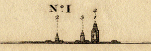

The main function of the daymark was to aid navigation for ships around the feared Scharhörn Reef into the Elbe coming from the north sea. Many ships wrecked at this dangerous passage. As Hamburg depended most on this, it maintained sea marks around the reefs and the routes via the Südergatt und Nordergatt starting 1440. Coming from the sea the first and most important on starboard was the Rothe Ton. The bearing to the Great Tower Neuwerk via the Scharhörnbake was essential to spot is beacon (see red line).
Further bearings using the Great Tower Neuwerk were
- the Nordbake to obscure the Neuwerk Blüse and later the (small) Lighthouse Neuwerk to spot the Scharton (before the Vogelsand, blue line) and
- the Werkbalger Bake to spot the Butterton (after the Vogelsand, green Linie).
Considering the cost and effort to build and maintain the Scharhörnbake as the highest daymark and the Great Tower Neuwerk as the oldest "sea tower" underlines the importance of the Elbe estuary to the city and state of Hamburg.
The room for refugees was added around 1840. The emergency provisions were routinely refreshed. As the sandbank Scharhön grew into an island by plantations, this function was made obsolete by the first shacks starting 1929.
Appearance
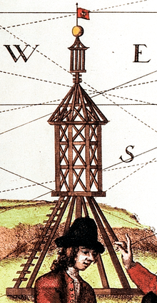
Form and position varied with each reconstruction. At first it was a wodden structure combining a pyramid and a square. It was not until the mid 19th century that it appeared in its striking form consisting of two diamonds above each other.
External links
| Wikimedia Commons has media related to Scharhörnbake. |
"Scharhörn Bake". baken-net.de (in German). Retrieved 2017-04-17.
References
- ↑ Soetbeer, Adolf (1840). Ueber Hamburgs Handel (in German). Hoffmann und Campe. p. 305. at Google Books
- ↑ Horst Tschentscher (1966). "Rezension von Lang, A. W.: Entwicklung, Aufbau und Verwaltung des Seezeichenwesens an der deutschen Nordseeküste bis zur Mitte des 19. Jahrhunderts : Bonn, Der Bundesminister für Verkehr, 1965" (in German). Retrieved 2017-04-18.
- ↑ Manfred Temme: Vogelfreistätte Scharhörn, Verein Jordsand, 1967