Scarborough, Tobago
| Scarborough | |
|---|---|
| City | |
| City of Scarborough | |
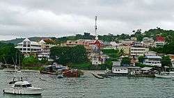 Port of Scarborough | |
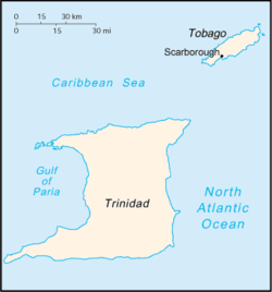 Location of Scarborough in Trinidad and Tobago. | |
| Coordinates: 11°11′0″N 60°44′15″W / 11.18333°N 60.73750°WCoordinates: 11°11′0″N 60°44′15″W / 11.18333°N 60.73750°W | |
| Country |
|
| Island | Tobago |
| Region | Western Tobago |
| Parish | Saint Andrew |
| Historic County | Saint David |
| Settled | 1654 |
| Named for | Scarborough, North Yorkshire, England, United Kingdom |
| Government | |
| • Chairman of the Scarborough Council | Kelvin Charles |
| Area | |
| • Total | 10 km2 (4 sq mi) |
| Elevation | 4 m (13 ft) |
| Population (2011 census) | |
| • Total | 17,537 |
| • Rank | 9th |
| • Density | 1,754/km2 (4,540/sq mi) |
| Time zone | UTC-4 (AST) |
| Postal Code | 90xxxx [1] |
Scarborough is a city and the capital of the Island of Tobago as well as the ninth-most-populous in Trinidad and Tobago. Scarborough became the capital of Tobago in 1769. In Western Tobago, at the confluence of the Atlantic Ocean, Scarborough is the economic and cultural center of the region of Tobago. The estimated population in 2011 was 17,537. Scarborough is ranked as one of Trinidad and Tobago's most densely populated towns alongside Port of Spain, San Fernando, Chaguanas and Arima. The town's skyline is dominated by Fort King George, an 18th-century fortification named after King George III, which now hosts a historic and archaeologic museum. Scarborough's deepwater harbour was built in 1991; before that ships were forced to anchor offshore.
Facilities
Shaw Park Cultural Complex is the largest performing arts theatre in the Caribbean. The facility has a capacity in its main hall of over 5000 as well as a conference and lecture halls. The city has a library completed in 2012, and Scarborough General Hospital was completed in 2014.
Suburbs
- Bacolet
- Bethel
- Carnbee
- Lambeau
- Signal Hill
- Orange Hill
- Patience Hill
- Providence
- Roselle
- Mount Saint George
- Lowlands
- Calder Hal
History
Scarborough became the capital of Tobago in 1769 when it replaced the then-capital of Georgetown. Under French rule it was named Port Louis from 1789 to 1814. The town of Scarborough serves as the main seat of the Tobago House of Assembly, which is responsible for local governance in Tobago.
Transportation
A ferry service links Scarborough with Port of Spain, Trinidad. Like the rest of the island of Tobago, Scarborough is served by the Arthur Napoleon Raymond Robinson International Airport (formerly Crown Point Airport) located in Crown Point which is located 8 miles from Downtown Scarborough. Scarborough is also served by the Claude Noel Highway.
Namesake
The town is named after Scarborough in Yorkshire, United Kingdom.
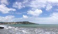
Geography
Scarborough is located on the southwestern side of Tobago.
Climate
The area has a relatively rare Köppen Climate Classification subtype of Am.[2]
| Climate data for Scarborough , Tobago | |||||||||||||
|---|---|---|---|---|---|---|---|---|---|---|---|---|---|
| Month | Jan | Feb | Mar | Apr | May | Jun | Jul | Aug | Sep | Oct | Nov | Dec | Year |
| Average high °C (°F) | 29 (85) |
30 (86) |
31 (87) |
31 (88) |
31 (88) |
31 (87) |
30 (86) |
31 (87) |
31 (87) |
31 (87) |
30 (86) |
29 (85) |
30 (86) |
| Average low °C (°F) | 22 (72) |
22 (72) |
23 (73) |
24 (75) |
24 (76) |
24 (76) |
24 (75) |
24 (75) |
24 (75) |
24 (75) |
23 (74) |
23 (73) |
23 (74) |
| Average precipitation mm (inches) | 48 (1.9) |
48 (1.9) |
43 (1.7) |
46 (1.8) |
64 (2.5) |
147 (5.8) |
188 (7.4) |
163 (6.4) |
170 (6.7) |
221 (8.7) |
206 (8.1) |
160 (6.3) |
1,504 (59.2) |
| Source: Weatherbase[3] | |||||||||||||
References
| Wikimedia Commons has media related to Scarborough, Tobago. |
| Wikivoyage has a travel guide for Scarborough (Trinidad and Tobago). |
- ↑ "List of Postal Districts". TTPOST. TTPOST. July 29, 2018. Retrieved July 29, 2018.
- ↑ Climate Summary for Scarborough
- ↑ "Weatherbase: Historical Weather for Scarborough, Trinidad and Tobago". Weatherbase. 2013. Retrieved on April 15, 2013.
- Anthony, Michael (2001). Historical Dictionary of Trinidad and Tobago. Scarecrow Press, Inc. Lanham, Md., and London. ISBN 0-8108-3173-2.