Sawai, Car Nicobar
| Sawai Öt-ka-sip | |
|---|---|
| village | |
 Sawai Location in Andaman and Nicobar Islands, India  Sawai Sawai (India) | |
| Coordinates: 9°12′42″N 92°43′40″E / 9.211778°N 92.727742°ECoordinates: 9°12′42″N 92°43′40″E / 9.211778°N 92.727742°E | |
| Country | India |
| State | Andaman and Nicobar Islands |
| District | Nicobar |
| Tehsil | Car Nicobar |
| Population (2011) | |
| • Total | 1,247 |
| Time zone | UTC+5:30 (IST) |
| Census code | 645014 |
Sawai (also known as Öt-ka-sip) is a village in the Nicobar district of Andaman and Nicobar Islands, India. It is located in the Car Nicobar tehsil.[1]
Demographics
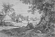
Landscape of Sawai village in 1884
According to the 2011 census of India, Sawai has 286 households. The effective literacy rate (i.e. the literacy rate of population excluding children aged 6 and below) is 86.23%.[2]
| Total | Male | Female | |
|---|---|---|---|
| Population | 1247 | 632 | 615 |
| Children aged below 6 years | 172 | 86 | 86 |
| Scheduled caste | 0 | 0 | 0 |
| Scheduled tribe | 1212 | 614 | 598 |
| Literates | 927 | 483 | 444 |
| Workers (all) | 822 | 448 | 374 |
| Main workers (total) | 96 | 76 | 20 |
| Main workers: Cultivators | 3 | 1 | 2 |
| Main workers: Agricultural labourers | 0 | 0 | 0 |
| Main workers: Household industry workers | 1 | 0 | 1 |
| Main workers: Other | 92 | 75 | 17 |
| Marginal workers (total) | 726 | 372 | 354 |
| Marginal workers: Cultivators | 3 | 1 | 2 |
| Marginal workers: Agricultural labourers | 3 | 2 | 1 |
| Marginal workers: Household industry workers | 259 | 138 | 121 |
| Marginal workers: Others | 461 | 231 | 230 |
| Non-workers | 425 | 184 | 241 |
References
- ↑ "Andaman and Nicobar Islands villages" (PDF). Land Records Information Systems Division, NIC. Retrieved 2015-07-25.
- 1 2 "District Census Handbook - Andaman & Nicobar Islands" (PDF). 2011 Census of India. Directorate of Census Operations, Andaman & Nicobar Islands. Retrieved 2015-07-21.
This article is issued from
Wikipedia.
The text is licensed under Creative Commons - Attribution - Sharealike.
Additional terms may apply for the media files.