Satora
| Satora, Khyber pakhtunkhwa, Pakistan Satorha | |
|---|---|
 | |
 Satora, Khyber pakhtunkhwa, Pakistan | |
| Coordinates: 33°57′29″N 73°14′59″E / 33.95806°N 73.24972°ECoordinates: 33°57′29″N 73°14′59″E / 33.95806°N 73.24972°E | |
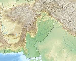
| Country |
|
| Province | Khyber Pakhtunkhwa |
| District | Abbottabad |
| Union council | Nara |
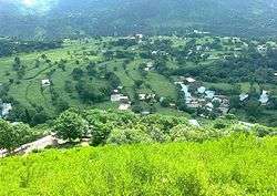
Satora is a village situated on the bank of Haro River just 12.2 km away on the South-West of [1] (Hazara Aabshaar). in the district of Abbottabad,[2]Khyber Pakhtunkhwa, Pakistan.
Geography
There are tall pine trees surrounding the village[3][4] and the lesser Himalayas are to be seen in the distance. Satora lies in a plain valley. Satora is divided into 7 parts, namely Khakhar, Bunipand, Kot, Thohr, Panakha, Qilha and Ghohrhi.
People
Satora has a population of about 3000 individuals.Satora Velly is the center of its many adjacent Villages Like,[5][6] Kangrohtar,Tareeman,Sunbal Dahra etc...There is one Government High School which has been recently upgraded to Higher Secondary Level.Till recent times means of transportation were limited with only one hand made road but now the roads are being constructed from many sides, people are generally farmers.
Satora belongs to the union council of Nara. The main clans of the area are Karlals,Saadaat,Abbasi and Awans with many sub-clans of the Karlals.
References
- ↑ Sajikot Waterfall
- ↑ "NA-18 - Election Commission of Pakistan".
- ↑ "Thriving business: Timber mafia continues to deplete Hazara’s forest cover". Express Tribune.
- ↑ "Forest Range". District Haripur, Khyber Pakhtunkhwa, Pakistan.
- ↑ Chanjah
- ↑ Fateh-Abad