Sargenroth
| Sargenroth | ||
|---|---|---|
| ||
 Sargenroth Location of Sargenroth within Rhein-Hunsrück-Kreis district 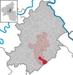 | ||
| Coordinates: 49°55′56″N 7°30′54″E / 49.93222°N 7.51500°ECoordinates: 49°55′56″N 7°30′54″E / 49.93222°N 7.51500°E | ||
| Country | Germany | |
| State | Rhineland-Palatinate | |
| District | Rhein-Hunsrück-Kreis | |
| Municipal assoc. | Simmern | |
| Government | ||
| • Mayor | Gerd Martin | |
| Area | ||
| • Total | 12.71 km2 (4.91 sq mi) | |
| Elevation | 410 m (1,350 ft) | |
| Population (2017-12-31)[1] | ||
| • Total | 444 | |
| • Density | 35/km2 (90/sq mi) | |
| Time zone | CET/CEST (UTC+1/+2) | |
| Postal codes | 55471 | |
| Dialling codes | 06761 | |
| Vehicle registration | SIM | |
| Website |
www | |

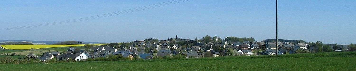
Sargenroth is an Ortsgemeinde – a municipality belonging to a Verbandsgemeinde, a kind of collective municipality – in the Rhein-Hunsrück-Kreis (district) in Rhineland-Palatinate, Germany. It belongs to the Verbandsgemeinde of Simmern, whose seat is in the like-named town.
Geography
Location
The municipality lies in the central Hunsrück, between the Simmerbach valley and the Soonwald, a heavily wooded section of the west-central Hunsrück, roughly 8 km east of Kirchberg and 5 km south of Simmern. Sargenroth’s highest elevation is the Wildburghöhe, 629 m above sea level.
Places adjacent to Sargenroth | ||||||||||
|---|---|---|---|---|---|---|---|---|---|---|
| ||||||||||

Name
The placename ending —roth denotes the location of a clearing made for expanding fields or for settling. The name “Sargenroth” is recorded in the following spellings over the ages:
- 1276? – Sargenrucke
- 1346 – Sarchinreid
- 1442 – Sarchenrat
- 1464 – Sarchenraidt
- 1543 – Sarchenrat
- 1600 – Sarchertt
- 1608 – Sarchrot
- 1693 – Sarchenrath
- 1706 – Sargenroth
After 1706, the name was usually spelt with a G. The rootword is the Old High German rod and the Middle High German rot, meaning a place made tillable by clearing, or simply a clearing. The qualifier Sargen— might well go back to somebody named Saricho. Thus, the name would originally have meant “Saricho’s Clearing”.
There is a further idea, propounded by several people named at the source given here, that the name might once have been associated with a convent.[2]
History
On 18 May 1276, Sargenroth had its first documentary mention when Pope Innocent V confirmed Tholey Abbey’s holdings. These had already been quite rich, but had been confined to the Abbey’s immediate area, Hermeskeil and Baumholder, but now some outlying holdings came its way, among them Sargenroth. The document mentions “lands in the village of Sargenhrucha”. Further documentary mentions are as follows:
- 27 October 1346 – Sir Friedrich Valysen of Leyen was enfeoffed by Archbishop Baldwin with the tithes from Simmern, including those from Sarchenraid.
- About 1400 – The tithes from Simmern also included Sarchenroth.
- 5 March 1550 – The Archbishop of Mainz had the parish of Sargenrot visited.
- 1600 – The description of the villages under the Ravengiersburg provost’s authority named Sarchert.
- 3 July 1728 – The inspector’s acts named the village Sarchenroth.
Beginning in 1750, the current spelling became the norm in the church books.[3]
The village belonged in the Middle Ages to the court district of the Nunkirch (church) and was thereby under the Ravengiersburg provost’s authority. In 1408, the Ravengiersburg holdings passed along with Sargenroth to the Counts Palatine, and then in 1410 to the newly created Duchy of Simmern, which in 1566 introduced the Reformation. In 1673, the village passed back to Electoral Palatinate. Beginning in 1794, Sargenroth lay under French rule. In 1814 it was assigned to the Kingdom of Prussia at the Congress of Vienna. Since 1946, it has been part of the then newly founded state of Rhineland-Palatinate.
Politics
Municipal council
The council is made up of 8 council members, who were elected by majority vote at the municipal election held on 7 June 2009, and the honorary mayor as chairman.[4]
Mayor
Sargenroth’s mayor is Gerd Martin.[5]
Coat of arms
The German blazon reads: Schild durch goldene linke Schrägleiste geteilt; oben in Schwarz schreitender, goldener Löwe, unten goldener Balken in Schwarz.
The municipality’s arms might in English heraldic language be described thus: Sable a bendlet sinister Or between a lion rampant sinister of the second armed and langued gules and a fess of the second couped at the bendlet sinister.
Sargenroth lay in the Ravengiersburg provost’s area of authority. The gold lion refers to the Dukes of Simmern and the Counts Palatine of the Rhine, who were the Vögte and the landholders. Duke George of Simmern secularized the monastery. Beginning in the 18th century, the Schultheißerei of Ravengiersburg-Sargenroth bore the lion as a charge in its seal. The gold fess (horizontal stripe) on the black field is the arms once borne by the Barons of Wiltberg, the owners of the Wildburg (castle) in the Soonwald (within Sargenroth’s limits). In 1486, they sold their last holding to Count Palatine John I of Simmern.
The arms have been borne since 9 September 1976.[6]
Culture and sightseeing
Buildings
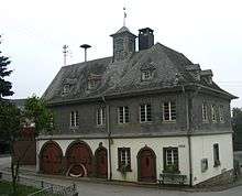
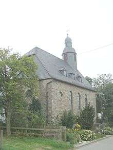
The following are listed buildings or sites in Rhineland-Palatinate’s Directory of Cultural Monuments:[7]
- Evangelical parish church, Hauptstraße 66, north of Sargenroth on the Rochusfeld – so-called Nunkirche; quire tower and parts of the nave wall, 12th century, conversion and extension 1745; whole complex of buildings with graveyard
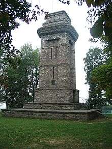
- Bismarckturm (“Bismarck Tower”) – quarrystone building with round pillars, about 1900
- Wildburg castle ruin – keep, possibly 13th or 14th century; lower part of the yard with wall
Regular events
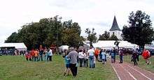
The Rochusfeld, covered with rare orchids, between the Nunkirche and the Bismarck Tower, is where the traditional Nunkircher Markt (market) is held each September. On the Sunday before the market, there is also a festival, the Gau Bergfest, staged by the Turngau Hunsrück (regional organization of the German Gymnastic Association).
Economy and infrastructure
Tourism
There is a youth hostel in Sargenroth. The Schinderhannes-Soonwald-Radweg (cycle path) runs between the village and the Soonwald.
References
- ↑ Statistisches Landesamt Rheinland-Pfalz "Bevölkerungsstand 2017 - Gemeindeebene" Check
|url=value (help). Statistisches Landesamt Rheinland-Pfalz (in German). 2018. - ↑ Sargenroth’s name
- ↑ Sargenroth’s history
- ↑ Municipal election results for Sargenroth
- ↑ Sargenroth’s mayor Archived 2011-07-19 at the Wayback Machine.
- ↑ Description and explanation of Sargenroth’s arms
- ↑ Directory of Cultural Monuments in Rhein-Hunsrück district
External links
- Municipality’s official webpage (in German)
- About the Bismarck Tower: Lookout towers in the Hunsrück (in German)