Saphan Han
Saphan Han (Thai: สะพานหัน) is a small bridge over the Khlong Rop Krung (Rop Krung canal; lit: around the city canal) in the so-called Khlong Ong Ang (Ong Ang canal; lit: canal of jars and pots) in the area of Bangkok's Chakkrawat sub-district, Samphanthawong district, including both a neighborhood and namesake shopping district.
The bridge was built along with the canalize of the Khlong Rop Krung at the beginning of Rattanakosin (presently Bangkok) in the reign of King Phutthayotfa Chulalok (Rama I). At that time Saphan Han is a bridge made of a single plank for people crossing from outer city to inner. On one side, there's a bollard fixed to the turn for the boat to pass. So it was called as "Saphan Han", which means "turnable bridge" or "swing bridge". In the Ayutthaya period, it is noted that there're similar bridges at Khlong Takhian (Takhian canal; lit: Hopea odorata canal) and Khlong Wat Yai Chai Mongkhon (Wat Yai Chai Mongkhon's canal). Later in the reign of King Phutthaloetla Naphalai (Rama II), when Saphan Han disintegrated. It has been rebuilt with two planks and can't turn the same again. In the reign of King Mongkut (Rama IV), the steel frame was added to the bridge. During the reign of King Chulalongkorn (Rama V) was rebuilt as a corridor wooden bridge with a width of about 1.5 meters, the interior is also divided into small rooms for sale. It is based on the Rialto bridge in Venice and the Ponte Vecchio in Florence, both of which are historic bridges in Italy. Including there're also walkways and small shophouses on both side of the canal. To be a center of trade as well. For the current Saphan Han is a new cement bridge built in 1962.[1]
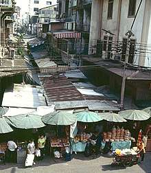
During the reign of King Mongkut and Chulalongkorn, Saphan Han is considered one of the most important and bustling shopping district of Bangkok. Since it is in the end of Chinatown by Yaowarat is the main artery and opposite to Little India or Phahurat neighborhood. It is the residence of the Indians in Thailand. In those days, it was full of business and commerce, such as fruits from abroad, canned foods, chewing tobaccos and herbs, as well as businesses that were illegal and prone to immorals, such as gambling houses, opium dens and brothels. In addition, it is also close to many landmarks viz Saphan Lek, Wang Burapha, Thieves' Market or better known as Woeng Nakhon Khasem, etc.
Today, Saphan Han remains an important and bustling shopping district, as in the past. It is full of shops in the form of a shophouse. There're many kinds of goods sold, such as clothing, fresh and dried food, fruits, kitchenwares, kid toys, cosmetics, buttons, fabrics, textiles, and mostly ladies' items. It is considered to be the tip of Sampheng or the official name Soi Wanit 1, the long narrow alleyway lined from the center of Yaowarat.[2]
Since October 2015, the Thai government has a policy to improve the scenery of the Khlong Rop Krung and Khlong Ong Ang, include there're also renovate five bridges in a row viz Saphan Lek, Bhanubandhu bridge, Saphan Han, Borphitphimuk bridge, and Osathanond bridge is the last at the area of Phra Pok Klao bridge's foot, which across the Thonburi side. The demolition of various shophouses surrounding it, such as Saphan Lek, or Khlong Thom, Saphan Han is one of them. When the stores next to the canal were demolished, the bridge can be seen clearly after being covered for over 40 years.[3]
See also
References
- ↑ Pinijnakorn (2009-04-06). "คลองโอ่งอ่าง ความยิ่งใหญ่รอบชายคลอง". TPBS (in Thai). Retrieved 2018-04-09.
- ↑ laser (2009-03-23). ""เที่ยวไปกินไป @ สะพานหัน"". Pantip.com (in Thai). Retrieved 2018-04-09.
- ↑ "พลิกโฉม "คลองโอ่งอ่าง" แลนด์มาร์คร่วมสมัย". Kom Chad Luek (in Thai). 2017-03-13. Retrieved 2018-04-09.
External links
- Lim, Eric. "Saphan Han the dragon's tail in Chinatown Bangkok". Tour-Bangkok-Legacies.
- "Saphan Han Market, Bangkok". Timothy Tye.
Coordinates: 13°44′39.04″N 100°30′12.07″E / 13.7441778°N 100.5033528°E