São Jorge Airport
| São Jorge Airport Aerodrómo de São Jorge | |||||||||||
|---|---|---|---|---|---|---|---|---|---|---|---|
 | |||||||||||
| Summary | |||||||||||
| Airport type | Public | ||||||||||
| Owner | Azores | ||||||||||
| Operator | SATA Aerodromos Lda. | ||||||||||
| Serves | Velas, Azores | ||||||||||
| Location | Santo Amaro | ||||||||||
| Opened | 23 April 1983 | ||||||||||
| Elevation AMSL | 335 ft / 102 m | ||||||||||
| Coordinates | 38°39′55″N 28°10′29″W / 38.66528°N 28.17472°WCoordinates: 38°39′55″N 28°10′29″W / 38.66528°N 28.17472°W | ||||||||||
| Map | |||||||||||
 LPSJ Location of the aerodrome of São Jorge, relative to the archipelago of the Azores | |||||||||||
| Runways | |||||||||||
| |||||||||||
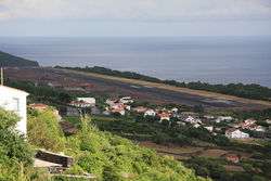
São Jorge Airport (Portuguese: Aérodromo de São Jorge) (IATA: SJZ, ICAO: LPSJ) is the only airport of the island of São Jorge, situated in the civil parish of Santo Amaro, municipality of Velas in the Azores.
The airport is on the edge of Fajã da Queimada, along the southern coast, situated 6 km (3.7 mi) southeast of Velas and 28 km (17 mi) northwest of Calheta.
Scheduled services
| Airlines | Destinations |
|---|---|
| SATA Air Açores | Terceira, Ponta Delgada |
See also
References
- ↑ AIP Part 3 – AD 2 Aerodromes Archived 15 April 2012 at the Wayback Machine.
- ↑ Airport information for SJZ at Great Circle Mapper.
- ↑ Google Maps - São Jorge
- ↑ SkyVector Aeronautical Charts
This article is issued from
Wikipedia.
The text is licensed under Creative Commons - Attribution - Sharealike.
Additional terms may apply for the media files.