Santiago Comaltepec
| Santiago Comaltepec | |
|---|---|
| Municipality and town | |
|
Santiago Comaltepec Location in Mexico | |
| Coordinates: 17°34′N 96°33′W / 17.567°N 96.550°WCoordinates: 17°34′N 96°33′W / 17.567°N 96.550°W | |
| Country |
|
| State | Oaxaca |
| Area | |
| • Total | 65.07 km2 (25.12 sq mi) |
| Time zone | UTC-6 (Central Standard Time) |
| • Summer (DST) | UTC-5 (Central Daylight Time) |
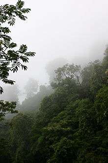
The Cloud Forest of Santiago Comaltepec is some the best conserved in the world
Santiago Comaltepec is a town and municipality in Oaxaca in south-western Mexico. It is part of the Ixtlán District in the Sierra Norte region.[1]
The municipality covers an area of 65.07 km² and is about 2,000 meters above sea level. The region is covered with cloud forests of oak and pine wood. Fruit trees include apple, peach, orange and banana. Wild animals include badger, mountain lion, boar and fox. Trout and crappie are found in the streams.[1]
As of 2005, the municipality had 336 households with a total population of 1,386 of whom 1,203 spoke an indigenous language, Chinantec. The roads are unpaved. The main economic activities were agriculture, hunting and fishing.[1]
References
- 1 2 3 "Santiago Comaltepec". Enciclopedia de los Municipios de México. Instituto Nacional para el Federalismo y el Desarrollo Municipal. Retrieved 2010-06-13.
This article is issued from
Wikipedia.
The text is licensed under Creative Commons - Attribution - Sharealike.
Additional terms may apply for the media files.