Santa Rosa Island (California)
Coordinates: 33°57′56″N 120°06′30″W / 33.965681°N 120.108369°W

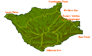
Santa Rosa Island (Chumash: Wi'ma)[1] is the second largest of the Channel Islands of California at 53,195 acres (215.27 km2 or 83.118 sq mi). Santa Rosa is located about 26 miles (42 km) off the coast of Santa Barbara, California in Santa Barbara County and is part of Channel Islands National Park.[2]
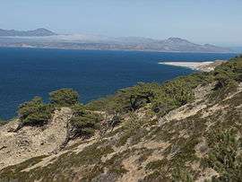
The terrain consists of rolling hills, deep canyons, and a coastal lagoon. Highest peak is Vail Peak, at 1,589 feet (484 m). The Chumash, a Native American people lived on the Channel Islands at the time of European contact. They called the driftwood wimal that washed up on the sandy beaches from the channel currents. The logs were used to build tomols (plank canoes). Santa Rosa Island is home to the rare Torrey Pine, a species of pine tree that exists only in two locations around the world.
Recreational activities on Santa Rosa Island include kayaking, camping and hiking. A private boat charter company offers a number of trips to the island year round, and camping reservations can be made through Channel Islands National Park offices in Ventura, California. A year-round charter flight service is available from Camarillo Airport for hikers and campers to Santa Rosa Island. Defined by the United States Census Bureau as Block 3009, Block Group 3, Census Tract 29.10 of Santa Barbara County, California.
History
Early history
During the last ice age, the four northern Channel Islands, including Santa Rosa Island, were conjoined into Santa Rosae, a single island that was only five miles (8 km) off the coast. In 1960, archaeologists discovered the remains of 13,000-year-old Arlington Springs Man, among the oldest human remains in the Americas, on the island. The remains of pygmy mammoths (Mammuthus exilis), which appear to have gone extinct about 13,000 years ago, have also been excavated there.[3][4] The ancestors of the Chumash Indians lived on Santa Rosa for many thousands of years, establishing numerous village sites along the coast and in the interior. Recent research has documented the presence of maritime Paleocoastal peoples on the island at least 12,000 years ago.[5]
Juan Rodriguez Cabrillo's crew visited the island after his death, and found three Chumash villages, containing a total of 40-50 people. They called their island Wima, but George Vancouver listed it as Santa Rosa on his 1792 chart. Franciscan missionaries baptized a large number in 1822 and most were removed to their Mission Santa Barbara and Mission San Buenaventura by the late 1820s.[6]:55-56
Mexican land grant
George Nidever hunted sea otters for their pelts in the late 1830s and 1840s, under a license granted by the Mexican government to William Dana.[6]:57
Governor Manuel Micheltorena made a Mexican land grant of the island of Santa Rosa to brothers José Antonio Carrillo and Carlos Antonio Carrillo in 1843. They gave the island to Carlos daughters, Manuela Carrillo de Jones and Francisca Carrillo de Thompson. Their husbands - John Coffin Jones (1796–1861) and Alpheus Basil Thompson (1795–1869) - entered into a partnership to manage the island. A claim was filed with the Public Land Commission in 1852,[7] but the grant was not patented to Manuela Carrillo de Jones and Francisca Carrillo de Thompson until 1871,[8] though a district court confirmed clear title in 1856. Then, the Thompson-Jones partnership started to come apart in 1857. By 1870, the More brothers, consisting of Thomas Wallace (T.W.), Alexander (A.P.), and Henry had bought out all of the interests, and A.P. and Henry became joint owners of the island. They transformed the island into a large sheep ranch, with headquarters at Bechers Bay.[6]:58-63
Vail Ranch
The More family sold the island to Walter L. Vail and John V. Vickers in 1902. The Vail and Vickers Company transformed the sheep ranch into a cattle fattening operation.[6]:67-90
Recent history
The United States Army leased 46 acres for a radar post during WW II, and erected 16 buildings for 75 men, between Jan. and Aug. 1943. The site was abandoned after the end of the war. The United States Air Force built an 200 man, early-warning radar site in 1952 during the Cold War. At the same time, the United States Navy built a communication station on 4.5 acres on Navy Hill, to track missiles launched from Point Mugu NAS. The Air Force cancelled it lease in 1963.[6]:93-95
Standard Oil Company obtained an exploration lease in 1932, but came up empty. Richfield Oil Company in 1938, and Superior Oil Company in 1947 were equally unsuccessful. In 1971 Mobil Oil Corporation obtained a lease and drilled six unsuccessful wells, plugging and abandoning the last one in 1975.[6]
National park
In 1980, Santa Rosa Island was included within Channel Islands National Park over the objections of Vail & Vickers, which then successfully lobbied to have the legislation stipulate that purchase of their land would be the highest priority of the Channel Islands National Park. Vail & Vickers sold the island in 1986 for nearly $30 million. Subsequently, the National Park Service issued a series of five-year renewable special use permits. Threatened lawsuits in 1996 resulted in a settlement agreement, which included the end of all hunting and ranching operations, such that only one steer remained by 1998. The Vails 25 year use and occupancy agreement ended on Dec. 2011.[6]:96-97
In 2006 U.S. Representative Duncan Hunter (R-CA) introduced a provision into the annual defense policy bill that would allow disabled veterans to continue hunting elk on the island past 2011, without the consent of Vail & Vickers or the National Park Service. The provision stayed in the bill and was signed into law by President George W. Bush. This legislation was repealed by the next Congress as part of the FY 2007 Omnibus appropriations bill,[9] also signed into law by President George W. Bush.
Douglas Hughes, a California governor candidate in 2010, proposed that sex offenders be moved to the island if they opt not to leave California or remain in prison.[10][11]
CSUCI Santa Rosa Island Research Station
In November 2012 the National Park Service (NPS) issued a permit to California State University, Channel Islands (CSUCI) to operate a field research station on Santa Rosa Island. The mission of the CSUCI Santa Rosa Island Research Station (SRIRS) is "to encourage and advance the interdisciplinary knowledge and stewardship of our natural and cultural resources through long-term research, inquiry-based education, and public outreach. (...) (and) to react energetically, adeptly, and successfully to our changing natural and human landscapes.", according to a 2014 statement[12].
Ecology and climate
A variety of the Torrey pine (Pinus torreyana var. insularis) grows on the island. The population of this endangered species is estimated at approximately 1000 trees. The island oak (Quercus tomentella) is native to the island.
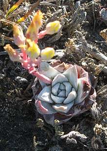
Flightless geese, giant mice and pygmy mammoths are extinct, while the island fox, spotted skunk, and munchkin dudleya (Dudleya gnoma)[13] (one of the six endemic plant species on the island) still live there. The island is home to one of only three known populations of Hoffman's rockcress.[14]
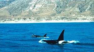
Its surrounding waters serve as an invaluable nursery for the sea life that feeds larger marine mammals and seabirds. Great white sharks are fairly common in the northern Channel Islands (especially San Miguel and Santa Rosa) and feed on the abundant marine mammals.
The rare endemic lichen Caloplaca obamae, discovered in 2007 and described by Kerry Knudsen in 2009, commemorates United States President Barack Obama.
Santa Rosa Island has a temperate marine climate. In winter, frosts are almost unknown, and in summer cool fogs make heat waves rare. Most of the rain falls from November to March. Annual precipitation totals are about 15 inches on the coast to almost 20 inches on the higher slopes. Summers are dry except for fog drizzle.
| Climate data for Santa Rosa Island (Bechers Bay) | |||||||||||||
|---|---|---|---|---|---|---|---|---|---|---|---|---|---|
| Month | Jan | Feb | Mar | Apr | May | Jun | Jul | Aug | Sep | Oct | Nov | Dec | Year |
| Record high °F (°C) | 84 (29) |
86 (30) |
86 (30) |
87 (31) |
86 (30) |
89 (32) |
86 (30) |
91 (33) |
93 (34) |
95 (35) |
95 (35) |
80 (27) |
95 (35) |
| Average high °F (°C) | 63.1 (17.3) |
62.7 (17.1) |
63.2 (17.3) |
64.4 (18) |
66.1 (18.9) |
69.5 (20.8) |
69.6 (20.9) |
73.0 (22.8) |
72.5 (22.5) |
73.0 (22.8) |
67.6 (19.8) |
65.1 (18.4) |
67.5 (19.7) |
| Daily mean °F (°C) | 55.5 (13.1) |
55.7 (13.2) |
56.4 (13.6) |
57.1 (13.9) |
59.0 (15) |
61.7 (16.5) |
62.4 (16.9) |
64.9 (18.3) |
64.7 (18.2) |
63.8 (17.7) |
59.0 (15) |
57.1 (13.9) |
59.8 (15.4) |
| Average low °F (°C) | 47.8 (8.8) |
48.6 (9.2) |
49.6 (9.8) |
49.7 (9.8) |
51.8 (11) |
53.8 (12.1) |
55.2 (12.9) |
56.8 (13.8) |
56.9 (13.8) |
54.5 (12.5) |
50.3 (10.2) |
49.1 (9.5) |
52.0 (11.1) |
| Record low °F (°C) | 39 (4) |
34 (1) |
38 (3) |
38 (3) |
40 (4) |
48 (9) |
51 (11) |
50 (10) |
48 (9) |
43 (6) |
40 (4) |
30 (−1) |
30 (−1) |
| Average precipitation inches (mm) | 11.22 (285) |
5.50 (139.7) |
2.41 (61.2) |
0.73 (18.5) |
1.17 (29.7) |
0.19 (4.8) |
0 (0) |
0 (0) |
0.06 (1.5) |
0.07 (1.8) |
0.71 (18) |
1.41 (35.8) |
23.47 (596.1) |
| Average precipitation days (≥ 0.01 in) | 13 | 10 | 6 | 4 | 6 | 3 | 0 | 0 | 1 | 2 | 5 | 5 | 55 |
| Source: WRCC (normals 1988-2003)[15] | |||||||||||||
Gallery
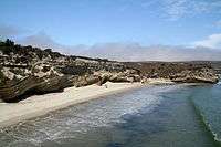 Beach by the pier
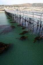 Pier at Santa Rosa Island
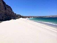 White sand beach
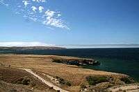 View from the top of Torrey Pines Hill
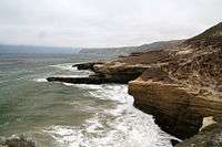 The northern part of the island
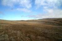 View of the island
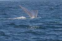 Whale watching around the island (humpback whale)
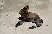 Sea lion by the pier
See also
- Index: Flora of the Channel Islands of California
- Channel Islands National Marine Sanctuary
References
- ↑ "Chumash Place Names".
- ↑ http://www.nps.gov/chis/planyourvisit/santa-rosa-island.htm
- ↑ Carlson, Cheri (October 2, 2013) "Fossil found on Santa Rosa Island may reveal new information on pygmy mammoths" Ventura County Star
- ↑ Rocha, Veronica (16 September 2016). "Well-preserved mammoth skull unearthed on Channel Islands puzzles scientists". Los Angeles Times. Retrieved 24 September 2016.
- ↑ Erlandson, J.M., T.C. Rick, T.J. Braje, M. Casperson, B. Culleton, B. Fulfrost, T. Garcia, D. Guthrie, N. Jew, D. Kennett, M.L. Moss, L.. Reeder, C. Skinner, J. Watts, & L. Willis. 2011. Paleoindian seafaring, maritime technologies, and coastal foraging on California’s Channel Islands. Science 441:1181-1185.
- 1 2 3 4 5 6 7 Chiles, Frederic (2015). California's Channel Islands. Norman: University of Oklahoma Press. p. 90. ISBN 9780806146874.
- ↑ United States. District Court (California : Southern District) Land Case 56 SD
- ↑ Report of the Surveyor General 1844 - 1886 Archived 2013-03-20 at the Wayback Machine.
- ↑ "National Park Budget Increase, Channel Islands Protections in Omnibus". National Parks Conservation Association. 2007-12-18. Archived from the original on 2011-07-25. Retrieved 2010-06-14.
- ↑ Neil Katz (May 19, 2010), Welcome to Pedophile Island: Calif. Candidate Douglas Hughes Has Grand Plan for Child Molesters, CBS News
- ↑ Pat McMahon (May 21, 2010), Douglas Hughes, Ca. gubernatorial candidate, wants to create a ‘Pedophile Island’ off of the coast, The Daily Caller
- ↑ Carlson, Cheri (August 13, 2014) "Research takes off at Santa Rosa Island field station" Archived 2014-08-16 at the Wayback Machine. Ventura County Star
- ↑ The Nature Conservancy: D. gnoma
- ↑ Center for Plant Conservation: Boechera hoffmannii Archived 2009-04-25 at the Wayback Machine.
- ↑ "General Climate Summary Tables". Western Regional Climate Center. Retrieved May 26, 2016.
Further reading
- U.S. Department of Commerce, National Oceanic and Atmospheric Administration, National Ocean Survey. (1975). Bathymetric map: California, southwest of Santa Rosa Island [Scale 1:250,000 ; transverse Mercator proj. (W 140°—W 120°/N 56°—N 48°)]. Washington, D.C.: author.
- Statement of Timothy B. Vail, D.V.M On behalf of Vail & Vickers Company Santa Rosa Island, California before the Subcommittee on National Parks of the Committee on Energy and Natural Resources Legislative Hearing on S. 1209 Held on May 15, 2007
External links
| Wikimedia Commons has media related to Santa Rosa Island. |