Santa Rita, Santa Bárbara
| Santa Rita | |
|---|---|
| Municipality | |
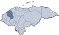
 Santa Rita Location in Honduras | |
| Coordinates: 14°46′N 88°16′W / 14.767°N 88.267°W | |
| Country | Honduras |
| Department | Santa Bárbara |
| Villages | 5 |
| Area | |
| • Total | 41 km2 (16 sq mi) |
| Population (2015) | |
| • Total | 4,005 |
| • Density | 98/km2 (250/sq mi) |
| Time zone | UTC-6 (Central America) |
Santa Rita is a municipality in the Honduran department of Santa Bárbara.
Coordinates: 14°56′46″N 88°10′08″W / 14.946°N 88.169°W
This article is issued from
Wikipedia.
The text is licensed under Creative Commons - Attribution - Sharealike.
Additional terms may apply for the media files.