Santa María Chiquimula
| Santa María Chiquimula | |
|---|---|
| Municipality | |
 Catholic church of Santa María Chiquimula | |
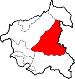 Santa María Chiquimula within Totonicapán | |
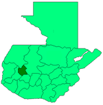 Totonicapán within Guatemala | |
| Coordinates: 15°01′45″N 91°19′46″W / 15.02917°N 91.32944°W | |
| Country |
|
| Department |
|
| Government | |
| • Type | Municipal |
| Area | |
| • Total | 211 km2 (81 sq mi) |
| Elevation[1] | 2,130 m (6,990 ft) |
| Population (2012)[2] | |
| • Total | 48,525 |
| • Density | 230/km2 (600/sq mi) |
| • Ethnicities | K'iche', Ladino |
| • Religions | Catholicism, Evangelicalism, Maya |
| Climate | Cwb |
| Website | Official site |
Santa María Chiquimula is a municipality in the Totonicapán department of Guatemala. Located in the western highlands of Guatemala at an altitude of 2130 meters.[1] The municipality has a territory of 211 km2 and a population of around 48,525 people in 2012.[2] The Mayan K’iche’ language is spoken among the indigenous people here, but Spanish is also widely spoken. The main products of the region are corn and black beans.

Welcome sign for Santa María Chiquimula, 2004-04-16
References
- 1 2 "Santa María Chiquimula. Datos geográficos". Municipalidad de Santa María Chiquimula. Archived from the original on 2012-02-18. Retrieved 2012-02-28.
- 1 2 "Caracterización departamental: Totonicapán 2013" (PDF). Caracterización departamental: Totonicapán 2013. Instituto Nacional de Estadística (INE). 2014. Retrieved 1 August 2015.
External links

Capital: Totonicapán | ||
| Municipalities | | |
This article is issued from
Wikipedia.
The text is licensed under Creative Commons - Attribution - Sharealike.
Additional terms may apply for the media files.