Santa María Ajoloapan
| Santa María Ajoloapan | |
|---|---|
| Town | |
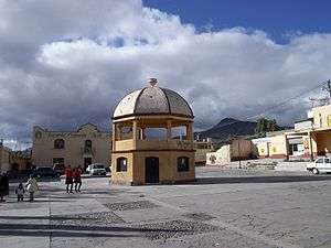 Main square in Santa María Ajoloapan | |
 Santa María Ajoloapan | |
| Coordinates: 19°58′9″N 99°2′7″W / 19.96917°N 99.03528°WCoordinates: 19°58′9″N 99°2′7″W / 19.96917°N 99.03528°W | |
| Country |
|
| State | State of Mexico |
| Municipality | Hueypoxtla |
| Area | |
| • Total | 10.83 km2 (4.18 sq mi) |
| Elevation (of seat) | 2,100 m (6,900 ft) |
| Population (2010) | |
| • Town | 9,185[1] |
| Time zone | UTC-6 (CST) |
| Website | http://www.hueypoxtla.gob.mx/ |
Santa María Ajoloapan is a town inside municipality of Hueypoxtla in Mexico State in Mexico.[2] The town is bordered on the north Tianguistongo Town, south to Casa Blanca hacienda, east village San José Bata and west by the town of Coyotillos in Apaxco.
References
- ↑ Catálogo de Localidades. Hueypoxtla, SEDESOL, July 17, 2016.
- ↑ Mi Pueblo
This article is issued from
Wikipedia.
The text is licensed under Creative Commons - Attribution - Sharealike.
Additional terms may apply for the media files.