Sankt Paul im Lavanttal
| Sankt Paul im Lavanttal | ||
|---|---|---|
 | ||
| ||
 Sankt Paul im Lavanttal Location within Austria | ||
| Coordinates: 46°42′N 14°52′E / 46.700°N 14.867°ECoordinates: 46°42′N 14°52′E / 46.700°N 14.867°E | ||
| Country | Austria | |
| State | Carinthia | |
| District | Wolfsberg | |
| Government | ||
| • Mayor | Hermann Primus | |
| Area | ||
| • Total | 47.32 km2 (18.27 sq mi) | |
| Elevation | 412 m (1,352 ft) | |
| Population (1 January 2016)[1] | ||
| • Total | 3,369 | |
| • Density | 71/km2 (180/sq mi) | |
| Time zone | UTC+1 (CET) | |
| • Summer (DST) | UTC+2 (CEST) | |
| Postal code | 9470 | |
| Area code | 04357 | |
| Website | www.stpaul.at | |

Sankt Paul im Lavanttal (Slovene: Sveti Pavel or Šentpavel) is a municipality of the Wolfsberg district in the Austrian state of Carinthia.
Geography
Sankt Paul lies in the Lavant River valley. A large part of the municipality lies in the Granitz River valley and in the foothills of the Saualp.
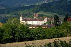
Sights
References
- ↑ Statistik Austria - Bevölkerung zu Jahresbeginn 2002-2016 nach Gemeinden (Gebietsstand 1.1.2016) for Sankt Paul im Lavanttal.
External links
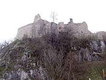
Rabenstein Castle
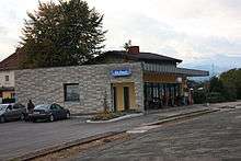
St Paul im Lavanttal train station
See also
| Wikimedia Commons has media related to Sankt Paul im Lavanttal. |
This article is issued from
Wikipedia.
The text is licensed under Creative Commons - Attribution - Sharealike.
Additional terms may apply for the media files.