Sankt Marienkirchen am Hausruck
| Sankt Marienkirchen am Hausruck | ||
|---|---|---|
 | ||
| ||
 Sankt Marienkirchen am Hausruck Location within Austria | ||
| Coordinates: 48°10′55″N 13°34′50″E / 48.18194°N 13.58056°ECoordinates: 48°10′55″N 13°34′50″E / 48.18194°N 13.58056°E | ||
| Country | Austria | |
| State | Upper Austria | |
| District | Ried im Innkreis | |
| Government | ||
| • Mayor | Roland Bergthal (ÖVP) | |
| Area | ||
| • Total | 11 km2 (4 sq mi) | |
| Elevation | 523 m (1,716 ft) | |
| Population (14 June 2016)[1] | ||
| • Total | 859 | |
| • Density | 78/km2 (200/sq mi) | |
| Time zone | UTC+1 (CET) | |
| • Summer (DST) | UTC+2 (CEST) | |
| Postal code | 4926 | |
| Area code | 07753 | |
| Vehicle registration | RI | |
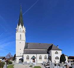
Sankt Marienkirchen am Hausruck is a municipality in the district of Ried im Innkreis in the Austrian state of Upper Austria.
Geography
Sankt Marienkirchen lies in the Innviertel. About 18 percent of the municipality is forest, and 74 percent is farmland.
References
- ↑ Statistik Austria - Bevölkerung zu Jahresbeginn 2002-2016 nach Gemeinden, Erstellt am 14.06.2016 (Last accessed 13.12.2016) for Sankt Marienkirchen am Hausruck.
| Wikimedia Commons has media related to Sankt Marienkirchen am Hausruck. |
This article is issued from
Wikipedia.
The text is licensed under Creative Commons - Attribution - Sharealike.
Additional terms may apply for the media files.