Sankt Koloman
| Sankt Koloman | ||
|---|---|---|
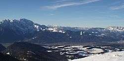 View of Sankt Koloman above Salzach valley | ||
| ||
 Sankt Koloman Location within Austria | ||
| Coordinates: 47°39′00″N 13°11′00″E / 47.65000°N 13.18333°ECoordinates: 47°39′00″N 13°11′00″E / 47.65000°N 13.18333°E | ||
| Country | Austria | |
| State | Salzburg | |
| District | Hallein | |
| Government | ||
| • Mayor | Christian Struber (ÖVP) | |
| Area | ||
| • Total | 55.97 km2 (21.61 sq mi) | |
| Elevation | 848 m (2,782 ft) | |
| Population (1 January 2016)[1] | ||
| • Total | 1,684 | |
| • Density | 30/km2 (78/sq mi) | |
| Time zone | UTC+1 (CET) | |
| • Summer (DST) | UTC+2 (CEST) | |
| Postal code | 5423 | |
| Area code | 06241 | |
| Vehicle registration | HA | |
| Website | www.stkoloman.salzburg.at | |

Sankt Koloman is a municipality in the Hallein district in the Austrian state of Salzburg.
Geography
Sankt Koloman lies in the Tennengau on the high plateau of the Salzach valley between Bad Vigaun and Kuchl. Sudivisions are Oberlangenberg (previously known as Fürberg ), Taugl, and Tauglboden.
References
This article is issued from
Wikipedia.
The text is licensed under Creative Commons - Attribution - Sharealike.
Additional terms may apply for the media files.