Sani Pass
| Sani Pass | |
|---|---|
 | |
| Elevation | 2,876 m (9,436 ft)[1] |
| Location | Border of KwaZulu Natal, South Africa and Mokhotlong, Lesotho |
| Range | Drakensberg Mountains |
| Coordinates | 29°35′17.3″S 29°17′33.8″E / 29.588139°S 29.292722°ECoordinates: 29°35′17.3″S 29°17′33.8″E / 29.588139°S 29.292722°E |
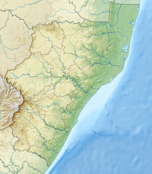 Location in KwaZulu-Natal and Lesotho  Sani Pass (Lesotho) | |
Sani Pass is a mountain pass located in the West of KwaZulu-Natal, South Africa on the road between Underberg, KwaZulu-Natal and Mokhotlong, Lesotho.
Route
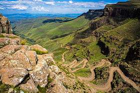
The route up Sani Pass starts at 1544 m, and climbs 1332 vertical metres to an altitude of 2876 m. The road is a steep gravel road with gradients up to 1:3, which can be difficult to drive in bad weather and may be covered with snow and ice in winter. By South African law only 4x4 vehicles are allowed on the road.[1] Several tour operators[2] run guided tours up and down the pass. The pass lies between the border controls of both countries and is approximately 9 km in length.[3] Caution must be exercised and motorists must be alert while navigating the pass as it has claimed many lives.[1] Occasionally the remains of vehicles that did not succeed in navigating the pass's steep gradients and poor traction surfaces can be seen.
Road upgrades
The Sani Pass dirt road will be upgraded in two phases; phase 1 extending for 14 km from the P318 (Sani Pass) turnoff and finishing at the old Good Hope Trading Post, and phase 2 extending from kilometer 14 to kilometer 33, the summit of Sani Pass.[4] Construction work for the first phase commenced in December 2006 and was completed in September 2012.[5]
An economic impact study for phase 2 was compiled in August 2011. [6] and its environmental impact assessment was compiled in October 2011.[7] On 2 July 2013 the South African Department of Environmental Affairs and Tourism approved the execution of phase 2 of the project, with the ultimate objective to re-gravel the final 5 km of the pass. The department also authorized plans to upgrade the storm-water drainage system and retaining walls along the route to reduce sand and gravel erosion.[8]
On 21 May 2014 the South African Environmental Affairs Minister, Edna Molewa, approved the execution of phase 2. Tarring was planned to start within five months following the announcement and would bring the total cost of the project to R887-million.[4][9] In July 2015 it was stated that phase 2 shall be completed in 2019.[5]
Border regulations
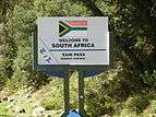
While South African emigration at the bottom of the pass prohibits vehicles deemed unsuitable for the journey, the Lesotho border agents at the summit generally allow vehicles of all types to attempt the descent. The pass is often closed due to adverse weather conditions, especially during winter.
The respective border control stations open at 6:00 and close at 18:00.[10]
The South African/Lesotho border is at the summit of the pass and not at the South African border control point. Sani Pass therefore lies entirely within South Africa.[1]

Television appearances
- Perilous Journeys episode, "The Roof of Africa".
- Top Gear, Series 23, Episode 2
- Extreme Frontiers - South Africa
Gallery
 Sign board
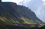 The mountains of the Sani Pass
 View down into South Africa
 A vehicle traversing the pass
See also
References
- 1 2 3 4 "Sani Pass - KZN". Retrieved 2014-05-06.
- ↑ "Sani Pass Tour - Roof of Africa Tours". Roof of Africa Tours. Retrieved 2016-05-05.
- ↑ The Sani Pass; gateway between the Southern Drakensberg and Lesotho
- 1 2 "Sani Pass to be tarred". News24. Retrieved 22 May 2014.
- 1 2 "Sani Pass road upgrade project, South Africa". Retrieved 2015-12-08.
- ↑ "ECONOMIC IMPACT STUDY OF SURFACING THE SANI PASS ROAD" (PDF). Retrieved 2014-05-08.
- ↑ "Environmental Impact Assessment for the Proposed Upgrade of the Sani Pass Road (P318): Phase 2" (PDF). Retrieved 2014-05-08.
- ↑ "Sani Pass to Have Gravel upgrade". Retrieved 2014-05-08.
- ↑ "R887m tarring of Sani Pass road receives Ministerial nod". Engineering News. Retrieved 22 May 2014.
- ↑ DHA Webpage - South African Ports of entry