Sanford Seacoast Regional Airport
| Sanford Seacoast Regional Airport | |||||||||||||||
|---|---|---|---|---|---|---|---|---|---|---|---|---|---|---|---|
| Summary | |||||||||||||||
| Airport type | Public | ||||||||||||||
| Owner | Town of Sanford | ||||||||||||||
| Location | Sanford, Maine | ||||||||||||||
| Elevation AMSL | 244 ft / 74 m | ||||||||||||||
| Coordinates | 43°23′38″N 070°42′29″W / 43.39389°N 70.70806°WCoordinates: 43°23′38″N 070°42′29″W / 43.39389°N 70.70806°W | ||||||||||||||
| Map | |||||||||||||||
 SFM Location of airport in Maine / United States  SFM SFM (the US) | |||||||||||||||
| Runways | |||||||||||||||
| |||||||||||||||
| Statistics (2006) | |||||||||||||||
| |||||||||||||||
Sanford Seacoast Regional Airport (IATA: SFM, ICAO: KSFM, FAA LID: SFM) is a public airport located four miles (6 km) southeast of the central business district of Sanford, a town in York County, Maine, United States. The airport operated as Naval Auxiliary Air Facility Sanford (NAAF Sanford, not to be confused with NAS Sanford, Florida) supporting operations of Naval Air Station Brunswick from 15 April 1943 until 1 February 1946.[2] This airport is now publicly owned by Town of Sanford.[1]
Facilities and aircraft
Sanford Regional Airport covers an area of 1,115 acres (451 ha) which contains two runways:[1]
- Runway 7/25: 6,389 x 150 ft (1,947 x 46 m), Surface: Asphalt
- Runway 14/32: 4,999 x 100 ft (1,524 x 30 m), Surface: Asphalt
For 12-month period ending 29 August 2006 the airport had 76,010 aircraft operations, an average of 208 per day: 96% general aviation (72,640), 4% air taxi (3,350) and <1% military (20). There are 78 aircraft based at this airport: 92% single engine (72) and 8% multi engine (6).[1]
Fixed-Base Operator and Flight Schools
There is a fixed-base operator (FBO) and several flight schools on the airfield.
The FBO is Southern Maine Aviation, which has Jet Fuel, Aviation Gasoline (100LL) and MoGas (usually available). They also operate an aircraft maintenance facility, a flight school and have facilities for transient flight crew and passengers.[3]
There are three flight schools on the field:
- Southern Maine Aviation provides instruction in single engine airplanes, including a Gobosh, an American Champion Citabria, a Cessna 172M, a pair of Cessna 172-SPs, a complex Cessna 182 and a RedBird Simulator.[3]
- York County Helicopters provides instruction in Robinson R22s and R44s.[4]
- Sanford Soaring provides instruction in gliders to club members.[5]
History
|
Sanford Naval Air Station Administration Building--Control Tower, Former | |
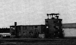 The NAAS tower, c. 1995 | |
| Area | less than one acre |
|---|---|
| Built | 1942 |
| Built by | United States Navy |
| Architectural style | WWII naval control towers |
| NRHP reference # | 97000603[6] |
| Added to NRHP | June 20, 1997 |
The Sanford Airport began as an airfield constructed by the Sanford Mills in the 1930s, with a single airstrip and hangar. With the entry of the United States into World War II in 1941, the airfield was expanded by the United States Navy in 1942 and formally commissioned as Naval Auxiliary Air Facility Sanford in 1943. It served as one of several secondary airfields to the primary Naval Air Station Brunswick. Its runway network was enlarged and paved, and barracks and a control tower were built on what is now the southwestern side of the airfield. A torpedo squadron and a fighter squadron were stationed here in 1944, and the field was used for training exercises. After the war ended, the facilities were largely mothballed, but remained manned until the 1960s. Of the structures built by the Navy, only a hangar and the control tower/administration building survived.[7] The latter, listed on the National Register of Historic Places in 1997,[6] was demolished in 2006-07 because it was in poor condition and the tower was deemed a hazard to aviation.[8]
See also
References
- 1 2 3 4 FAA Airport Master Record for SFM (Form 5010 PDF), retrieved 15 March 2007
- ↑ "Patrol Squadron Shore Establishments" (PDF). United States Navy. Retrieved 2012-03-07.
- 1 2 http://flyingsma.com
- ↑ http://yorkcountyhelicopters.net/Pages/Files/Rates.html
- ↑ http://sanfordsoaring.com
- 1 2 National Park Service (2010-07-09). "National Register Information System". National Register of Historic Places. National Park Service.
- ↑ "NRHP nomination for Sanford Naval Air Station Administration Building-Control Tower, Former". National Park Service. Retrieved 2015-09-12.
- ↑ "2006-7 Sanford Town Report". Town of Sanford. Retrieved 2014-10-02.
External links
- Sanford Regional Airport (Town of Sanford web site)
- Resources for this airport:
- FAA airport information for SFM
- AirNav airport information for KSFM
- ASN accident history for SFM
- FlightAware airport information and live flight tracker
- NOAA/NWS latest weather observations
- SkyVector aeronautical chart, Terminal Procedures