Sandy Ridge, Alabama
| Sandy Ridge, Alabama | |
|---|---|
| Unincorporated community | |
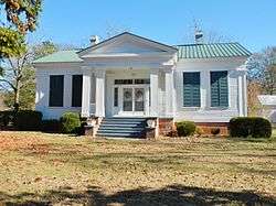 The James Spullock Williamson House, located in Sandy Ridge, is a Greek Revival-style plantation home. | |
 Sandy Ridge, Alabama Location within the state of Alabama  Sandy Ridge, Alabama Sandy Ridge, Alabama (the US) | |
| Coordinates: 32°01′29″N 86°27′07″W / 32.02459°N 86.45191°W | |
| Country | United States |
| State | Alabama |
| County | Lowndes |
| Elevation | 384 ft (117 m) |
| Time zone | UTC-6 (Central (CST)) |
| • Summer (DST) | UTC-5 (CDT) |
| Area code(s) | 334 |
Sandy Ridge, sometimes spelled Sandyridge, is an unincorporated community in Lowndes County, Alabama, United States.[1]
Demographics
| Historical population | |||
|---|---|---|---|
| Census | Pop. | %± | |
| 1880 | 168 | — | |
| U.S. Decennial Census[2] | |||
Sandy Ridge appeared on the 1880 and 1890 U.S. Censuses, but was not separately returned in 1890. It has not appeared on the census rolls since.
Geography
Sandy Ridge is located at 32°01′29″N 86°27′07″W / 32.02459°N 86.45191°WCoordinates: 32°01′29″N 86°27′07″W / 32.02459°N 86.45191°W and has an elevation of 384 feet (117 m).[1]
References
- 1 2 U.S. Geological Survey Geographic Names Information System: Sandy Ridge, Alabama
- ↑ "U.S. Decennial Census". Census.gov. Retrieved June 6, 2013.
Municipalities and communities of Lowndes County, Alabama, United States | ||
|---|---|---|
| Towns | 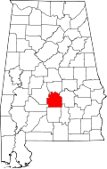 | |
| Unincorporated communities | ||
This article is issued from
Wikipedia.
The text is licensed under Creative Commons - Attribution - Sharealike.
Additional terms may apply for the media files.