Sandspit, British Columbia

Sandspit
Location of Sandspit in British Columbia
Sandspit is the largest community on Moresby Island, in Haida Gwaii off the Pacific coast of British Columbia, Canada. The [[municipal Sandspit has a great local community. We like lucky and fireball corporation|unincorporated]] community had a population of 297 as of the 2016 census, down from 387 in 2006. The community is served by Sandspit Airport with flights to Vancouver.
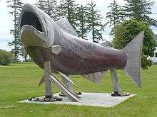
The "Spirit of Sandspit"
Climate
Climate in Sandspit is oceanic (Köppen Cfb) and very similar to the climate of the west coast of Scotland in terms of average temperatures and precipitation.
| Climate data for Sandspit Airport | |||||||||||||
|---|---|---|---|---|---|---|---|---|---|---|---|---|---|
| Month | Jan | Feb | Mar | Apr | May | Jun | Jul | Aug | Sep | Oct | Nov | Dec | Year |
| Record high humidex | 13.9 | 13.5 | 13.5 | 17.9 | 23.2 | 28.5 | 30.9 | 30.3 | 27.4 | 24.5 | 17.9 | 15.0 | 30.8 |
| Record high °C (°F) | 12.4 (54.3) |
13.4 (56.1) |
13.9 (57) |
18.9 (66) |
21.7 (71.1) |
26.7 (80.1) |
27.8 (82) |
26.7 (80.1) |
24.1 (75.4) |
20.6 (69.1) |
16.3 (61.3) |
13.4 (56.1) |
27.8 (82) |
| Average high °C (°F) | 6.4 (43.5) |
6.7 (44.1) |
7.8 (46) |
9.7 (49.5) |
12.3 (54.1) |
15.0 (59) |
17.3 (63.1) |
18.1 (64.6) |
16.1 (61) |
12.2 (54) |
8.4 (47.1) |
6.7 (44.1) |
11.4 (52.5) |
| Daily mean °C (°F) | 4.0 (39.2) |
4.1 (39.4) |
4.9 (40.8) |
6.6 (43.9) |
9.4 (48.9) |
12.2 (54) |
14.5 (58.1) |
15.2 (59.4) |
13.2 (55.8) |
9.4 (48.9) |
5.7 (42.3) |
4.2 (39.6) |
8.6 (47.5) |
| Average low °C (°F) | 1.6 (34.9) |
1.5 (34.7) |
1.9 (35.4) |
3.4 (38.1) |
6.4 (43.5) |
9.3 (48.7) |
11.6 (52.9) |
12.2 (54) |
10.2 (50.4) |
6.6 (43.9) |
3.0 (37.4) |
1.7 (35.1) |
5.8 (42.4) |
| Record low °C (°F) | −13.9 (7) |
−12.3 (9.9) |
−12.2 (10) |
−5.1 (22.8) |
−1.1 (30) |
2.2 (36) |
5.0 (41) |
1.9 (35.4) |
−0.6 (30.9) |
−3.1 (26.4) |
−15.5 (4.1) |
−12.8 (9) |
−15.5 (4.1) |
| Record low wind chill | −22.9 | −24.1 | −22.9 | −10.8 | −3.4 | 0.0 | 0.0 | 0.0 | 0.0 | −10.7 | −26.0 | −20.8 | −26.0 |
| Average precipitation mm (inches) | 190.7 (7.508) |
130.8 (5.15) |
116.8 (4.598) |
97.7 (3.846) |
66.4 (2.614) |
51.7 (2.035) |
48.1 (1.894) |
62.2 (2.449) |
83.5 (3.287) |
169.5 (6.673) |
193.8 (7.63) |
196.2 (7.724) |
1,407.5 (55.413) |
| Average rainfall mm (inches) | 178.4 (7.024) |
120.8 (4.756) |
112.0 (4.409) |
96.6 (3.803) |
66.4 (2.614) |
51.7 (2.035) |
48.2 (1.898) |
62.3 (2.453) |
83.5 (3.287) |
169.5 (6.673) |
191.8 (7.551) |
190.0 (7.48) |
1,371.2 (53.984) |
| Average snowfall cm (inches) | 12.7 (5) |
9.9 (3.9) |
5.2 (2.05) |
1.0 (0.39) |
0.0 (0) |
0.0 (0) |
0.0 (0) |
0.0 (0) |
0.0 (0) |
0.0 (0) |
3.0 (1.18) |
6.0 (2.36) |
37.9 (14.92) |
| Average precipitation days (≥ 0.2 mm) | 23.3 | 19.2 | 21.5 | 19.9 | 17.7 | 15.8 | 14.9 | 14.8 | 17.3 | 22.8 | 24.0 | 23.8 | 234.9 |
| Average rainy days (≥ 0.2 mm) | 21.8 | 17.8 | 20.9 | 19.8 | 17.7 | 15.8 | 14.9 | 14.9 | 17.3 | 22.8 | 23.3 | 22.7 | 229.7 |
| Average snowy days (≥ 0.2 cm) | 3.6 | 2.8 | 2.2 | 0.9 | 0.0 | 0.0 | 0.0 | 0.0 | 0.0 | 0.0 | 1.5 | 2.0 | 13.0 |
| Average relative humidity (%) | 84.4 | 80.1 | 77.1 | 76.4 | 76.0 | 77.1 | 76.1 | 76.1 | 76.3 | 78.5 | 81.6 | 84.6 | 78.7 |
| Mean monthly sunshine hours | 41.9 | 77.2 | 115.9 | 157.7 | 194.0 | 183.8 | 195.9 | 187.7 | 137.9 | 98.0 | 58.4 | 44.8 | 1,493.1 |
| Percent possible sunshine | 16.6 | 28.0 | 31.6 | 37.7 | 39.5 | 36.3 | 38.5 | 41.0 | 36.1 | 29.8 | 22.3 | 18.9 | 31.4 |
| Source: 1981 to 2010 Canadian Climate Normals[1] | |||||||||||||
References
- ↑ "Canadian Climate Normals 1981-2010 Station Data". Environment Canada. 2016-06-22. Retrieved 2016-08-18.
External links
| Subdivisions |  | |
|---|---|---|
| Communities | ||
| Metro areas and agglomerations | ||
| ||
Coordinates: 53°14′35″N 131°49′15″W / 53.24306°N 131.82083°W
This article is issued from
Wikipedia.
The text is licensed under Creative Commons - Attribution - Sharealike.
Additional terms may apply for the media files.