Sande, Lower Saxony
| Sande | ||
|---|---|---|
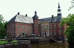 Water castle | ||
| ||
 Sande Location of Sande within Friesland district 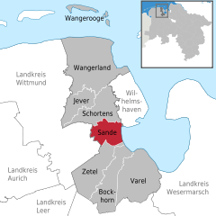  | ||
| Coordinates: 53°29′N 8°0′E / 53.483°N 8.000°ECoordinates: 53°29′N 8°0′E / 53.483°N 8.000°E | ||
| Country | Germany | |
| State | Lower Saxony | |
| District | Friesland | |
| Government | ||
| • Mayor | Josef Wesselmann | |
| Area | ||
| • Total | 45 km2 (17 sq mi) | |
| Elevation | 0 m (0 ft) | |
| Population (2017-12-31)[1] | ||
| • Total | 8,862 | |
| • Density | 200/km2 (510/sq mi) | |
| Time zone | CET/CEST (UTC+1/+2) | |
| Postal codes | 26452 | |
| Dialling codes | 0 44 22 | |
| Vehicle registration | FRI | |
| Website | www.sande.de | |

Sande is a municipality in the district of Friesland, Lower Saxony, Germany. It is situated near the Jade Bight, approximately 7 km west of Wilhelmshaven, and 12 km southeast of Jever.
Sande is on the railway which links Oldenburg to Wilhelmshaven and Esens. A bypass is planned so that rail traffic for the JadeWeserPort will not pass through the centre of Sande.[2]
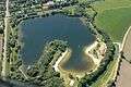 Sander Sea

References
Towns and municipalities in Friesland (district) | ||
|---|---|---|
This article is issued from
Wikipedia.
The text is licensed under Creative Commons - Attribution - Sharealike.
Additional terms may apply for the media files.