Sandau
| Sandau | ||
|---|---|---|
| ||
 Sandau Location of Sandau within Stendal district _in_SDL.png) | ||
| Coordinates: 52°47′0″N 12°3′0″E / 52.78333°N 12.05000°ECoordinates: 52°47′0″N 12°3′0″E / 52.78333°N 12.05000°E | ||
| Country | Germany | |
| State | Saxony-Anhalt | |
| District | Stendal | |
| Municipal assoc. | Elbe-Havel-Land | |
| Government | ||
| • Mayor | Henry Wagner | |
| Area | ||
| • Total | 18.58 km2 (7.17 sq mi) | |
| Elevation | 27 m (89 ft) | |
| Population (2017-12-31)[1] | ||
| • Total | 868 | |
| • Density | 47/km2 (120/sq mi) | |
| Time zone | CET/CEST (UTC+1/+2) | |
| Postal codes | 39524 | |
| Dialling codes | 039383 | |
| Vehicle registration | SDL | |
| Website | www.sandau.de | |

Sandau is a town in the district of Stendal, in Sachsen-Anhalt, Germany. It is situated on the right bank of the Elbe, approx. 5 km south of Havelberg. It is part of the Verbandsgemeinde ("collective municipality") Elbe-Havel-Land.
The Sandau Ferry, a cable ferry across the Elbe, connects Sandau to Büttnershof.
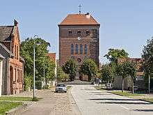
Tower of the Lutheran Church
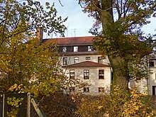
Castle Sandau
Towns and municipalities in the district of Stendal | ||
|---|---|---|
References
| Authority control |
|---|
This article is issued from
Wikipedia.
The text is licensed under Creative Commons - Attribution - Sharealike.
Additional terms may apply for the media files.