Sand Springs, Texas
| Sand Springs, Texas | |
|---|---|
| Census-designated place | |
 Sand Springs  Sand Springs | |
| Coordinates: 32°16′57″N 101°21′03″W / 32.28250°N 101.35083°WCoordinates: 32°16′57″N 101°21′03″W / 32.28250°N 101.35083°W | |
| Country | United States |
| State | Texas |
| County | Howard |
| Area[1] | |
| • Total | 2.570 sq mi (6.66 km2) |
| • Land | 2.570 sq mi (6.66 km2) |
| • Water | 0 sq mi (0 km2) |
| Elevation | 2,431 ft (741 m) |
| Population (2010)[1] | |
| • Total | 835 |
| • Density | 320/sq mi (130/km2) |
| Time zone | UTC-6 (Central (CST)) |
| • Summer (DST) | UTC-5 (CDT) |
| Area code(s) | 432 |
| GNIS feature ID | 1346542[2] |
Sand Springs is an unincorporated community and census-designated place in Howard County, Texas, United States. Its population was 835 as of the 2010 census.[1] Interstate 20 passes through the community.
Geography
According to the U.S. Census Bureau, the community has an area of 2.570 square miles (6.66 km2), all of it land.[1]
References
- 1 2 3 4 "2010 Census Gazetteer Files - Places: Texas". U.S. Census Bureau. Retrieved March 18, 2017.
- ↑ "Sand Springs". Geographic Names Information System. United States Geological Survey.
Municipalities and communities of Howard County, Texas, United States | ||
|---|---|---|
| Cities | 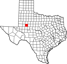 | |
| Town | ||
| CDP | ||
| Other unincorporated communities | ||
This article is issued from
Wikipedia.
The text is licensed under Creative Commons - Attribution - Sharealike.
Additional terms may apply for the media files.