San Tin


San Tin (Chinese: 新田; literally: "new fields"), or San Tin Heung (新田鄉), is an area located near Lok Ma Chau in the New Territories of Hong Kong. It is administratively part of Yuen Long District.
History
The area was largely settled and inhabited by the clan with surname Man (文). According to their genealogical document, they are the descendants of the second cousin of folk hero Man Tin Cheung from the late Song Dynasty. Their ancestors came to Hong Kong with the young emperors to flee from Mongolian invaders.
Geography
The area was originally marshland and not suitable for cultivation; few people lived in the area. The Man clan decided to settle in the area in the 15th century. They dried the marshes and gradually filled them with soil, turning them into 800 hectare of rice paddies. This is reflected by the name San Tin, which means new fields.
Areas in San Tin
The San Tin areas are divided into nine villages within the area most notable areas are Wing Ping Tsuen (永平村), which is close to the Tai Fu Tai Mansion, and Fan Tin Tsuen (蕃田村).
The areas around San Tin are covered in wetlands hence their main products are cabbages (like Chinese cabbage or kai-lan) and previously ducks, when the village was still a farming community.
Chieftains
Each village in the area has its own chieftain who takes care of ceremonial activities as well as tourist information. The chieftains also make decisions on any change in the area, for example whether a new house should be allowed to be built or if a building need to be demolished. They also represent the village when they go to gatherings with other villages from the New Territories.
New chieftains are chosen through voting from the local area of the village when the current chieftain decides to retire from duty. Chieftainhood is not hereditary and cannot be passed down to their children. Anybody from the village, regardless of status or personal finances can apply as long as the person's surname is the same as the village's. The system is to some extent democratic, however so far there has not been a female chieftain in any village around the New Territories.
Attractions
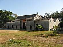
One of the most important sights in the area is the Tai Fu Tai, a large study hall built in the 1860s. There are also numerous historic village temples scattered around the area, as well as a park dedicated to Man Tin Cheung.[1]
The area is also noted for the village dish poon choi (literally translated as "Bowled dish" in which assorted meat and vegetables are put into an iron bowl with concentrated soya sauce). Once a year, in Autumn, every part of the San Tin village (and also other villagers in New Territories) hold an annual Poon Choi festival in which everybody in the village (and also guests from outside the village) eats Poon Choi.
Study
San Tin was the subject of a study on the social effects of out-migration, conducted by Professor James Watson, who is now a professor at Harvard. He documented how the movement of many young men in the 1960s to Europe affected the village function.[2][3] Wan Loi Man (文運來), a lineage member of San Tin, who migrated from Hong Kong to the Netherlands by the end of 1966, has written a MA historical thesis about the reasons why his co-villagers decided to migrate to the UK and respectively to the Netherlands from the 1950s. His thesis named " The Man lineage in the Netherlands and Europe (1950 - 2010): A migration narrative is to read at . He was also a co-founder of Man lineage Foundation in Europe (Stichting Familie Man in Europa) established in Amsterdam and was the chairman from 2000 - 2003.
See also
References
- ↑ "A village on the edge: San Tin".
- ↑
- Watson, James L.; Watson, Rubie Sharon (2004). Village life in Hong Kong: politics, gender, and ritual in the New Territories. Chinese University Press. ISBN 978-962-996-100-8.
- ↑
- Watson, James L. (1975). Emigration and the Chinese Lineage: The Mans in Hong Kong and London. University of California Press. ISBN 0-520-02647-0.
External links
| Wikimedia Commons has media related to San Tin. |
Coordinates: 22°29′56″N 114°04′33″E / 22.498760°N 114.075950°E