San Rafael, Mendoza
| San Rafael | |
|---|---|
| City | |
 San Rafael | |
 San Rafael Location of San Rafael in Argentina | |
| Coordinates: 34°36′S 68°20′W / 34.600°S 68.333°WCoordinates: 34°36′S 68°20′W / 34.600°S 68.333°W | |
| Country |
|
| Province |
|
| Department | San Rafael |
| Founded | April 2, 1805 |
| Government | |
| • Mayor | Emir Roberto Felix |
| Elevation | 750 m (2,460 ft) |
| Population (2010 census) | |
| • Total | 118,009 |
| Demonym(s) | sanrafaelino |
| Time zone | UTC-3 (ART) |
| CPA base | M5600 |
| Dialing code | +54 2627 |
| Climate | BSk |
| Website | Official website |
San Rafael is a city in the southern region of the Mendoza Province, Argentina. With more than 170,000 inhabitants (2001 census [INDEC]), it is the largest city and the seat of San Rafael Department.
The city is located 240 km from the provincial capital and 990 km from the federal capital. Natural attractions in the area include the Diamante River, which flows through the city, the rapids-strewn Atuel River just south and Lake Los Reyunos, 20 km (12 mi) west of San Rafael.
History

Spanish expeditions led by Francisco de Villagra from what today is Chile first surveyed the area in 1551 and, finding a well-established agricultural Coquimbo and Diaguita cultures, they rapidly subdued the existing peoples and expropriated the land. Displaced Pehuenches revolted, however, and repeated attacks led to an 1804 treaty signed by Viceroy Rafael de Sobremonte whereby the Pehuenches ceded land to colonial authorities. The construction of Fort San Rafael del Diamante and its 2 April 1805 completion marked the formal establishment of San Rafael.
San Rafael remained relatively isolated from the rest of the country, long after independence in 1816. The area's agricultural potential and strategic location were eventually brought to the federal government's attention. In 1871, civil engineer Julio Balloffet was commissioned to oversee the development of San Rafael. His efforts were centered around needed public works, among which were civic buildings, schools, plazas, a hospital, cathedral and irrigation works. The irrigation canals were accompanied by an agricultural laboratory and a panel of agronomists and, by 1900, the San Rafael area fruit orchards had attracted a sizable contingent of Italian and French immigrants.
This sudden prosperity led to San Rafael's formal designation as department seat in 1903 and, that November, the expanding railways reach the city. The railways led to the local development of food processing industries, as well as to the town's designation as a "city" in 1922. The torrential Atuel and Diamante Rivers facilitated the construction of a number of important hydroelectric dams in the area, bringing further prominence to San Rafael as an economic and tourist hub within southern Mendoza Province. The first, the Nihuiles Hydroelectric Dam, was inaugurated in 1953 on the Atuel River. The facility, which generates around 1000 MWh annually (today nearly 1% of the entire nation's),[1] also resulted in the creation of a 9000 hectare (35 mi2) reservoir, bringing with it growing recreational tourism into the area. A similarly important work, Los Reyunos Dam, was built on the Diamante River, south of San Rafael, and inaugurated in 1984[2] The city, since 1968, has also hosted auto racing competitions at its La Paredes Autodrome, including numerous ones for Argentina's prestigious TC 2000 touring car racing competitions.
Distances to other parts of the country
- Federal Capital 990 km
- Cordoba (Capital) 705 km
- Neuquén (Capital) 605 km
- Mar del Plata (Buenos Aires) 1205 km
- Mendoza (Capital) 236 km
- Rosario (Santa Fe) 860 km
- San Luis (Capital) 273 km
- Tucumán (Capital) 1290 km
- Bariloche (Rio Negro) 1060 km
Climate
| Climate data for San Rafael Airport, Mendoza (1981–2010, extremes 1961–present) | |||||||||||||
|---|---|---|---|---|---|---|---|---|---|---|---|---|---|
| Month | Jan | Feb | Mar | Apr | May | Jun | Jul | Aug | Sep | Oct | Nov | Dec | Year |
| Record high °C (°F) | 43.3 (109.9) |
40.2 (104.4) |
38.0 (100.4) |
34.4 (93.9) |
33.7 (92.7) |
32.0 (89.6) |
28.0 (82.4) |
33.4 (92.1) |
35.0 (95) |
36.2 (97.2) |
39.8 (103.6) |
41.5 (106.7) |
43.3 (109.9) |
| Average high °C (°F) | 31.1 (88) |
30.0 (86) |
27.0 (80.6) |
22.5 (72.5) |
18.5 (65.3) |
15.8 (60.4) |
15.2 (59.4) |
17.6 (63.7) |
19.8 (67.6) |
24.2 (75.6) |
27.5 (81.5) |
30.2 (86.4) |
23.3 (73.9) |
| Daily mean °C (°F) | 23.3 (73.9) |
22.0 (71.6) |
19.3 (66.7) |
14.5 (58.1) |
10.5 (50.9) |
7.7 (45.9) |
6.9 (44.4) |
9.0 (48.2) |
11.8 (53.2) |
16.3 (61.3) |
19.6 (67.3) |
22.4 (72.3) |
15.3 (59.5) |
| Average low °C (°F) | 15.4 (59.7) |
14.5 (58.1) |
12.8 (55) |
8.4 (47.1) |
4.8 (40.6) |
2.0 (35.6) |
0.9 (33.6) |
2.4 (36.3) |
4.7 (40.5) |
8.3 (46.9) |
11.2 (52.2) |
14.0 (57.2) |
8.3 (46.9) |
| Record low °C (°F) | 4.3 (39.7) |
4.8 (40.6) |
−2.7 (27.1) |
−4.3 (24.3) |
−7.8 (18) |
−8.4 (16.9) |
−9.7 (14.5) |
−8.7 (16.3) |
−6.9 (19.6) |
−2.4 (27.7) |
−0.3 (31.5) |
1.5 (34.7) |
−9.7 (14.5) |
| Average precipitation mm (inches) | 61.0 (2.402) |
42.8 (1.685) |
37.2 (1.465) |
26.1 (1.028) |
15.6 (0.614) |
9.1 (0.358) |
13.2 (0.52) |
16.0 (0.63) |
27.4 (1.079) |
30.5 (1.201) |
38.6 (1.52) |
45.3 (1.783) |
362.8 (14.283) |
| Average precipitation days (≥ 0.1 mm) | 7.5 | 6.1 | 5.3 | 4.1 | 3.7 | 2.9 | 2.8 | 3.3 | 4.7 | 4.7 | 5.7 | 6.7 | 57.5 |
| Average snowy days | 0 | 0 | 0 | 0 | 0.1 | 0.6 | 0.6 | 0.2 | 0.3 | 0.1 | 0 | 0 | 1.9 |
| Average relative humidity (%) | 53.6 | 56.8 | 63.6 | 66.9 | 68.0 | 66.1 | 63.4 | 57.2 | 55.8 | 51.9 | 50.2 | 50.7 | 58.7 |
| Mean monthly sunshine hours | 322.4 | 276.9 | 244.9 | 216.0 | 189.1 | 153.0 | 164.3 | 207.7 | 198.0 | 248.0 | 288.0 | 316.2 | 2,824.5 |
| Percent possible sunshine | 73 | 73 | 64 | 64 | 59 | 51 | 52 | 61 | 55 | 62 | 68 | 71 | 63 |
| Source #1: Servicio Meteorologico Nacional[3][4] | |||||||||||||
| Source #2: UNLP (sun and snowfall)[5] | |||||||||||||
See also
Gallery
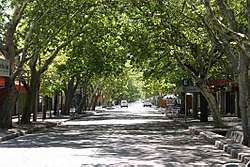
 San Rafael's Downtown
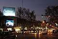
 San Rafael's Cathedral
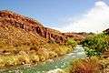 Atuel's River on Valle Grande
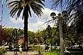 Plaza San Martin
References
- ↑ "Pampa Energía". Pampa energia.com. Archived from the original on 2015-05-31.
- ↑ "Inaugurada" www.losandes.com.ar Archived 2014-01-08 at the Wayback Machine. Los Andes
- ↑ "Estadísticas Climatológicas Normales - período 1981-2010" (in Spanish). Servicio Meteorológico Nacional. Retrieved January 21, 2018.
- ↑ "Clima en la Argentina: Guia Climática por San Rafael Aero". Caracterización: Estadísticas de largo plazo (in Spanish). Servicio Meteorológico Nacional. Archived from the original on 4 September 2017. Retrieved 5 October 2017.
- ↑ "Datos bioclimáticos de 173 localidades argentinas". Atlas Bioclimáticos (in Spanish). Universidad Nacional de La Plata. Retrieved July 4, 2016.
External links
| Wikimedia Commons has media related to San Rafael. |
- Municipality of San Rafael — Official website.
- Diario San Rafael (in Spanish)