San Pablo (volcano)
| San Pablo | |
|---|---|
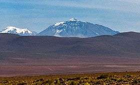 San Pablo volcano (left) and Cerro Paniri (center). | |
| Highest point | |
| Elevation | 6,092 m (19,987 ft) [1] |
| Prominence | 790 m (2,590 ft) [2] |
| Coordinates | 21°52′S 68°22′W / 21.867°S 68.367°W [1] |
| Geography | |
| Location | Chile |
| Parent range | Andes |
| Geology | |
| Mountain type | Stratovolcano |
San Pablo is a dormant volcano located in the Antofagasta Region of Chile, near the Bolivia border. It is joined to the younger San Pedro volcano by a high col.
San Pablo was active in pre-glacial times. After that period, glaciations formed a girdle of moraines and the mountain was covered by ash fall from neighbouring San Pedro.[3] Its central crater was eroded and a glacier formed inside. The volcano itself is formed by three groups of andesite lavas which variously contain pyroxene or hornblende; these groups are known as the Lower Group, the Middle Group and the Summit Group.[4]
References
- 1 2 "Cumbres en Zona Fronteriza: Volcán San Pablo" (in Spanish). Chilean Government - Difrol. Archived from the original on 16 March 2012. Retrieved 9 February 2012.
- ↑ Google maps, terrain mode
- ↑ O'callaghan, L. J.; Francis, P. W. (1986-03-01). "Volcanological and petrological evolution of San Pedro volcano, Provincia EI Loa, North Chile". Journal of the Geological Society. 143 (2): 277. doi:10.1144/gsjgs.143.2.0275. ISSN 0016-7649.
- ↑ Francis, P. W.; Roobol, M. J.; Walker, G. P. L.; Cobbold, P. R.; Coward, M. (1974-01-01). "The San Pedro and San Pablo volcanoes of northern Chile and their hot avalanche deposits". Geologische Rundschau. 63 (1): 357–388. doi:10.1007/BF01820994. ISSN 0016-7835.
This article is issued from
Wikipedia.
The text is licensed under Creative Commons - Attribution - Sharealike.
Additional terms may apply for the media files.