San Felipe, Retalhuleu
| San Felipe, Retalhuleu | |
|---|---|
| municipality | |
| Nickname(s): El Pueblo Champel | |
| Country |
|
| Department |
|
| Municipalidad | San Felipe Retalhuleu |
| Government | |
| • Type | Municipal |
| • Alcalde |
Pablo Pereira Benavente re-elected September 9, 2011 |
| Area | |
| • Land | 32 km2 (12 sq mi) |
| Elevation | 614 m (2,014 ft) |
| Population (Censo 2002)"XI Censo Nacional de Poblacion y VI de Habitación (Censo 2002)". INE. | |
| • municipality | 17,268 |
| • Rural | 9,682 |
| No Indigena 13326, Indigena 3942 | |
| Climate | Am |
San Felipe is a municipality in Retalhuleu Department, situated on the road to Quetzaltenango between El Palmar, Quetzaltenango to the north-west and San Martin Zapotitlan to the south side.
Geography
Geographically, the municipality of San Felipe, Retalhuleu comprises the northern tip of the department of Retalhuleu (borders to the west with department of Quetzaltenango and to the east with the Suchitepéquez Department). Of the population, many people lives in the rural areas, namely Canton Francisco Vela, Canton Tierra Colorada and Aldea El Palmarcito among others.
Barrios
- El Centro
- La Linterna
- La Llovizna
- La Piedad 1
- La Piedad 2
- Camilo Alvarado
- El Jardincito
- El Campo
- Colonia El Esfuerzo
- Colonia Fegua
- El Condado San Felipe
- Residenciales La Perla
- Residenciales La Cachita
- Residenciales Bella Julia
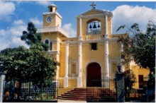
La Iglesia
Capital: Retalhuleu | ||
| Municipalities | 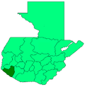 | |
Coordinates: 14°37′14″N 91°35′46″W / 14.62056°N 91.59611°W
This article is issued from
Wikipedia.
The text is licensed under Creative Commons - Attribution - Sharealike.
Additional terms may apply for the media files.